Geolocate

Gunung Lang topographic map

Click on the map to display elevation.

About this map

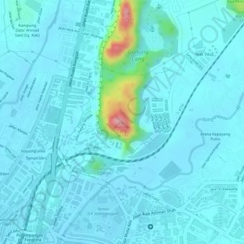
Name: Gunung Lang topographic map, elevation, terrain.

Location: Gunung Lang, Ipoh, Kinta, Perak, 30450, Malaysia (4.61419 101.08596 4.61429 101.08606)

Average elevation: 177 ft

Minimum elevation: 121 ft

Maximum elevation: 571 ft

Other topographic maps

Click on a map to view its topography, its elevation and its terrain.

Kampung Baru Bukit Merah

Malaysia > Perak > Ipoh

Average elevation: 184 ft

Mirror lake

Malaysia > Perak > Ipoh

Average elevation: 262 ft

Kampung Jawa

Malaysia > Perak > Ipoh

Average elevation: 148 ft

Gear up for your next adventure:

🦶Carbon Trekking Poles - Reduce knee impact on steep descents with ultra-light poles
🚑Emergency Bivvies - Heat-reflective sleeping bags for survival situations
🏔️Mountain Trail Maps - High‑detail maps for popular peaks
📱Solar Portable Charger - Solar power bank for charging devices off‑grid
🛶Inflatable Kayak - Portable kayak for rivers, lakes, and expeditions

As an Amazon Associate, this site earns from qualifying purchases at no extra cost to you.