
Make a donation
Gear up for your next adventure:
As an Amazon Associate, this site earns from qualifying purchases at no extra cost to you.
Nelson topographic map
Click on the map to display elevation.
Make a donation
Gear up for your next adventure:
As an Amazon Associate, this site earns from qualifying purchases at no extra cost to you.
About this map
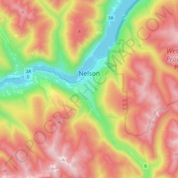
Name: Nelson topographic map, elevation, terrain.
Average elevation: 4,347 ft
Minimum elevation: 1,726 ft
Maximum elevation: 7,185 ft
Make a donation
Gear up for your next adventure:
As an Amazon Associate, this site earns from qualifying purchases at no extra cost to you.
Other topographic maps
Click on a map to view its topography, its elevation and its terrain.
Halcyon
Canada > British Columbia > Regional District of Central Kootenay > Area K (The Arrow Lakes)
Average elevation: 2,365 ft
Mount Cooper
Canada > British Columbia > Regional District of Central Kootenay > Area D (Lardeau Valley/Duncan Lake)
Average elevation: 8,140 ft
Blewett
Canada > British Columbia > Regional District of Central Kootenay > Area E (Balfour/Cottonwood Lake) > Blewett
Average elevation: 2,746 ft
Mount Stanley
Canada > British Columbia > Regional District of Central Kootenay > Area J (Lower Arrow/Columbia)
Average elevation: 6,490 ft
Make a donation
Gear up for your next adventure:
As an Amazon Associate, this site earns from qualifying purchases at no extra cost to you.