Geolocate

Bulacan topographic map

Click on the map to display elevation.

About this map

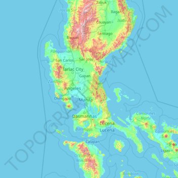
Name: Bulacan topographic map, elevation, terrain.

Location: Bulacan, Central Luzon, Philippines (12.40000 118.48333 17.60000 123.68333)

Average elevation: 344 ft

Minimum elevation: -3 ft

Maximum elevation: 9,272 ft

Other topographic maps

Click on a map to view its topography, its elevation and its terrain.

Cagayan de Oro

Philippines

Cagayan de Oro, located along the north-central coast of Mindanao, Philippines, encompasses a diverse topography that significantly influences its terrain. The city spans approximately 488.86 square kilometers (188.75 square miles), featuring a 25-kilometer (16 miles) coastline along Macajalar Bay. The…

Average elevation: 735 ft

Cagayan Valley

Philippines

Average elevation: 243 ft

T'Boli

Philippines > South Cotabato

Average elevation: 2,598 ft

Cebu

Philippines

Coal was first discovered in Cebu about 1837. There were 15 localities over the whole island, on both coasts; some desultory mining had been carried out Naga near Mount Uling, but most serious operations were at Licos and Camansi west of Compostela and Danao. Active work ceased about 1895 with insurrections,…

Average elevation: 299 ft

Malolos

Philippines > Bulacan

Malolos is relatively flat of about 0.81% to a gently sloping of 2.17%. The slope of the land descends towards west, southwest to southern direction. The highest land elevation is at about 6.0 m (19.7 ft) above sea level while the lowest is only 0.5 m (1 ft 8 in) below sea level. A network of natural waterways…

Average elevation: 13 ft

Rio Grande River

Philippines > Cavite > General Trias

Average elevation: 69 ft

Tagaytay

Philippines > Cavite

It is one of the country's most popular destinations for domestic tourism because of its scenery and cooler climate provided by its altitude. Tagaytay overlooks Taal Lake in Batangas and provides views of Taal Volcano Island in the middle of the lake through various vantage points situated in the city.

Average elevation: 1,165 ft

Nasugbu

Philippines > Batangas

Average elevation: 233 ft

Mandaluyong

Philippines

Another claims that the Spaniards named the place based on the report of a navigator named Acapulco, who saw the rolling hills frequently being lashed at by daluyong (“big waves from the sea”). This seems to confirm traditional pre-Hispanic stories that giant waves from the sea would meet the adjoining…

Average elevation: 56 ft

Palawan

Philippines

Palawan's almost 2,000 kilometers (1,200 mi) of irregular coastline is lined with rocky coves and sugar-white sandy beaches. It also harbors a vast stretch of virgin forests that carpet its chain of mountain ranges. The mountain heights average 1,100 meters (3,500 ft) in altitude, with the highest peak rising…

Average elevation: 115 ft

Masbate

Philippines

The general surface configuration of the province ranges from slightly undulating to rolling and from hilly to mountainous. In each island, the rugged topography is concentrated in the northeastern portion and gradually recedes to blunt hills and rolling areas in the south, southeast, and southwest.

Average elevation: 92 ft

Camarines Sur

Philippines

Average elevation: 190 ft

Alfonso

Philippines > Cavite

Average elevation: 1,309 ft

San Fernando

Philippines

Average elevation: 49 ft

Ilayang Dupay

Philippines > Lucena

Average elevation: 174 ft

Tagum

Philippines > Davao del Norte

One of the significant accomplishments of the officialdom of Tagum during the 1990s was its elevation from a second to the first-class municipality. This opened a gateway to increase its financial resources through the Internal Revenue Allocation (IRA) from the national government and local revenues. This was…

Average elevation: 299 ft

Lapaz District Plaza

Philippines > Iloilo City

Average elevation: 16 ft

Tigbauan

Philippines > Iloilo

Average elevation: 75 ft

Soccsksargen

Philippines

Average elevation: 725 ft

Lake Holon

Philippines > South Cotabato > T'Boli

Average elevation: 4,764 ft

Tagbilaran

Philippines > Bohol

Average elevation: 82 ft

Sta. Rita EcoPark

Philippines > Pampanga > San Isidro

Average elevation: 69 ft

Paombong

Philippines > Bulacan

Average elevation: 7 ft

Candaba

Philippines > Pampanga

Average elevation: 79 ft

Benguet

Philippines > Benguet

Average elevation: 2,897 ft

Ilocos Norte

Philippines > Ilocos Norte

Average elevation: 853 ft

Siquijor

Philippines > Siquijor

Average elevation: 56 ft

Aklan

Philippines > Aklan

Mount Nausang, is the previous highest peak in Aklan, standing at 5,138 ft (1,566 m), but Mount Madi-ac is higher, with an elevation of 1,716 m (5,630 ft) above sea level, located 6 km northwest of Mount Nausang and 4.8 km northeast of Mount Madja-as. Aklan River, is the longest river in the province with a…

Average elevation: 308 ft

Abra

Philippines > Abra

Average elevation: 1,972 ft

Apayao

Philippines

Average elevation: 1,316 ft

Ifugao

Philippines > Ifugao

Average elevation: 2,982 ft

Kalinga

Philippines > Kalinga

Average elevation: 2,175 ft

Metro Manila

Philippines

The Coastal Margin or Lowland is a flat and low plain that faces Manila Bay. Located here is the City of Manila, Navotas, parts of Malabon, and the western part and reclaimed areas of Pasay and Parañaque, where the ground elevation ranges from zero (0) meters on Manila Bay to five (5) meters at the west side…

Average elevation: 141 ft

Ilocos Sur

Philippines > Ilocos Sur

Average elevation: 1,535 ft

Pangasinan

Philippines > Pangasinan

Average elevation: 948 ft

La Union

Philippines > La Union

Average elevation: 1,440 ft

Cagayan

Philippines > Cagayan

The eastern coast forms the northern portion of the Sierra Madre mountain range, while the western limits are generally hilly to low in elevation. The central area, dominated by a large valley, forms the lower basin of the country's longest river, the Cagayan. The mouth is located at the northern town of…

Average elevation: 361 ft

Cavite

Philippines > Cavite

Another theory proposes that the name is a Hispanicized form of kabit, Tagalog for "joined", "connected", or "attached", referring to the peninsula's topographical relation to the mainland. Edmund Roberts, in his 1821 memoir, stated that the "natives" called it Caveit due to the "crooked point of land…

Average elevation: 285 ft

San Francisco

Philippines > Laguna > San Pablo > San Francisco

Average elevation: 344 ft

Batangas

Philippines > Batangas

Batangas is a combination of plains and mountains, including one of the world's smallest volcanoes, Mt. Taal, with an elevation of 600 metres (2,000 ft), located in the middle of the Taal Lake. Other important peaks are Mount Macolod with an elevation of 830 metres (2,720 ft), Mt. Banoy with 960 metres (3,150…

Average elevation: 387 ft

Camarines Norte

Philippines > Camarines Norte

Average elevation: 154 ft

Negros Occidental

Philippines > Negros Occidental

Average elevation: 410 ft

Guimaras

Philippines > Guimaras

Average elevation: 43 ft

Iloilo

Philippines > Iloilo

The province is divided into two distinct geographic regions; the highlands of the Central Panay Mountain Range on the western border and the lowland plains which account for a larger portion of the province. Small islands east of its northernmost tip also dot the Visayan Sea - of these, Pan de Azucar and…

Average elevation: 423 ft

Negros Oriental

Philippines > Negros Oriental

The province's topography is characterized by low, grooved mountain ranges of which some lie close to the shoreline. At the southern end of the province is Mount Talinis, also known as Cuernos de Negros ("Horns of Negros"), which is a dormant complex volcano which rises to a height of 2,000 metres (6,600 ft).…

Average elevation: 381 ft

Eastern Samar

Philippines > Eastern Samar

Average elevation: 200 ft

Northern Samar

Philippines > Northern Samar

Average elevation: 135 ft

Southern Leyte

Philippines > Southern Leyte

Along with other mountain forms in the province, Mount Nacolod in Hinunangan town has the highest peak with an elevation of 948 metres (3,110 ft) above sea level. Young volcanic rocks are discovered in the terrain areas, which cover the top of the southern mountain ranges of Mount Cabalian in the Pacific Area…

Average elevation: 217 ft

Zamboanga del Norte

Philippines > Zamboanga del Norte

It has an average elevation of 243.8 metres (800 ft), with Mount Dabiak in Katipunan as the highest peak at 2,600 metres (8,500 ft). Other parts, near the coastlines, are plains. The province's irregular coastline runs some 400 kilometres (250 mi) from north to south.

Average elevation: 253 ft

Zamboanga del Sur

Philippines > Zamboanga del Sur

Average elevation: 495 ft

Zamboanga Sibugay

Philippines > Zamboanga Sibugay

Average elevation: 312 ft

Camiguin

Philippines > Camiguin

Camiguin Island is a pearl-shaped island with an area of approximately 238 km2 (92 sq mi). The island measures about 23 kilometres (14 mi) at its longest and 14.5 kilometres (9.0 mi) at its widest breadth. The island is mountainous with the highest elevation reaching over 5,000 ft (1,500 m). It is encircled by…

Average elevation: 112 ft

Misamis Oriental

Philippines > Misamis Oriental

Average elevation: 1,079 ft

Davao del Norte

Philippines > Davao del Norte

Average elevation: 1,339 ft

Davao Oriental

Philippines > Davao Oriental

Average elevation: 476 ft

Davao del Sur

Philippines > Davao del Sur

The province enjoys a mild, pleasant climate all year round. Because of its topographical characteristics and geographical location, it is rarely visited by typhoons. There is no pronounced wet or dry season. The coolest months are from November to February with an average temperature of 25 °C (77 °F).…

Average elevation: 938 ft

South Cotabato

Philippines > South Cotabato

Maximum daytime temperature throughout the province is in the range of 36 to 38 °C (97 to 100 °F), falling to 23 to 32 °C (73 to 90 °F) during the night depending on the elevation. The hottest period is January to April while July to December being the coolest.

Average elevation: 1,155 ft

North Cotabato

Philippines > North Cotabato

Average elevation: 1,270 ft

Sultan Kudarat

Philippines > Sultan Kudarat

Average elevation: 797 ft

Agusan del Norte

Philippines > Agusan del Norte

Average elevation: 774 ft

Agusan del Sur

Philippines > Agusan del Sur

Average elevation: 1,070 ft

Surigao del Norte

Philippines > Surigao del Norte

Average elevation: 207 ft

Surigao del Sur

Philippines > Surigao del Sur

Average elevation: 381 ft

Dinagat Island

Philippines > Dinagat Islands

Average elevation: 95 ft

Makati

Philippines > Makati

Average elevation: 46 ft

Meycauayan

Philippines > Bulacan > Meycauayan

Average elevation: 46 ft

Sarangani

Philippines > Sarangani

Average elevation: 846 ft

Alabang

Philippines > Muntinlupa

Average elevation: 49 ft

Irrigation

Philippines > Leyte > Ormoc

Average elevation: 95 ft

Panay Island

Philippines > Catanduanes > Quigaray

Average elevation: 49 ft

Parañaque

Philippines > Parañaque

Average elevation: 43 ft

Balbagon Island

Philippines > Iloilo > Carles

Average elevation: 0 ft

Taal

Philippines > Batangas > Taal

Average elevation: 194 ft

Angat River

Philippines > Bulacan > Pulilan

Average elevation: 23 ft

Blue Lagoon

Philippines > Ilocos Norte > Pagudpud

Average elevation: 121 ft

Caloocan

Philippines

South Caloocan, where most commercial and industrial establishments are found, lies on generally flat and highly accessible land, with slopes ranging from 0-3%. The topography gradually changes into gently to moderately sloping to rolling along the North Luzon Expressway, with slopes ranging from 3-18%. The…

Average elevation: 59 ft

Barangay 102

Philippines > Pasay

Average elevation: 26 ft

La Trinidad

Philippines > Benguet

The terrain is generally mountainous with springs, rivers and creeks. The town has a valley which encompasses several barangays. The valley floor elevation is at 1,300 metres (4,300 ft) above sea level. Elevation ranges from 500 to 1,700 metres (1,600 to 5,600 ft) above sea level.

Average elevation: 3,691 ft

Lipa

Philippines > Batangas

At the celebration of the elevation of Lipa to a city in January 1888, José Rizal was invited by Dr. Jose Lozada, Catalino Dimayuga and the brothers Celestino and Simeon Luz but Rizal responded only with his Hymno Al Trabajo which he dedicated to the zeal and industry of the Lipeños.

Average elevation: 814 ft

Mandaue

Philippines

It is one of the two (the other one being the municipality of Consolacion) local government units located within the mainland Metro Cebu where the elevation of land is less than 100 m (330 ft).

Average elevation: 102 ft

Gear up for your next adventure:

🌄Hiking Binoculars - Compact binoculars for scenic views and trail spotting
🏕️Tent Footprint - Protect your tent base from wear
🧤Tactile Hiking Gloves - Keep hands warm while operating GPS and smartphone screens
🧯Portable Fire Pit - Compact fire pit for camping spots
🪓Survival Multi‑Tool - Versatile tool for camp and trail tasks

As an Amazon Associate, this site earns from qualifying purchases at no extra cost to you.