Geolocate

Inabanga topographic map

Click on the map to display elevation.

About this map

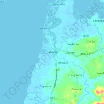
Name: Inabanga topographic map, elevation, terrain.

Location: Inabanga, Bohol, Central Visayas, Philippines (9.99191 124.02615 10.07191 124.10615)

Average elevation: 20 ft

Minimum elevation: -16 ft

Maximum elevation: 259 ft

Other topographic maps

Click on a map to view its topography, its elevation and its terrain.

Tabalong

Philippines > Bohol > Dauis

Average elevation: 62 ft

Pamilacan Island

Philippines > Bohol > Pamilacan

Average elevation: 7 ft

Maribojoc

Philippines > Bohol

Average elevation: 223 ft

Malinao Dam

Philippines > Bohol > Del Pilar

Average elevation: 499 ft

Tagbilaran

Philippines > Bohol

Average elevation: 82 ft

Bingag

Philippines > Bohol > Dauis

Average elevation: 62 ft

creek

Philippines > Bohol > Duero

Average elevation: 39 ft

Biking

Philippines > Bohol > Dauis

Average elevation: 187 ft

Candijay

Philippines > Bohol

Average elevation: 312 ft

Batas Island

Philippines > Bohol > Batasan

Average elevation: 0 ft

Gear up for your next adventure:

🔭Telescopic Hiking Pole - Adjustable pole for hiking stability
😴Insulated Sleeping Pads - Compact and warm pads for high-elevation camping
🥘Titanium Cookware - Durable, featherlight pots and pans for backpacking
🗺️NatGeo Topo Maps - High-quality waterproof printed topographic maps of US Parks
📦Gear Storage Bags - Organize and protect outdoor equipment

As an Amazon Associate, this site earns from qualifying purchases at no extra cost to you.