Geolocate

Hayden topographic map

Interactive map

Click on the map to display elevation.

About this map

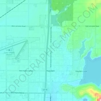
Name: Hayden topographic map, elevation, terrain.

Location: Hayden, Kootenai County, Idaho, United States (47.74169 -116.85115 47.80257 -116.75338)

Average elevation: 2,326 ft

Minimum elevation: 2,218 ft

Maximum elevation: 3,045 ft

According to the United States Census Bureau, the city has a total area of 9.61 square miles (24.89 km2), of which 9.60 square miles (24.86 km2) is land and 0.01 square miles (0.03 km2) is water. It lies at the southwestern end of Hayden Lake, and the elevation of the city is 2,287 feet (697 m) above sea level.

Wikipedia (CC-BY-SA 3.0)

Other topographic maps

Click on a map to view its topography, its elevation and its terrain.

Post Falls

United States > Idaho > Kootenai County

Post Falls, Kootenai County, Idaho, 83854, United States

Average elevation: 2,329 ft

Coeur d'Alene

United States > Idaho > Kootenai County

Coeur d'Alene, Kootenai County, Idaho, 83815, United States

Average elevation: 2,359 ft

Hauser

United States > Idaho > Kootenai County

Hauser, Kootenai County, Idaho, United States

Average elevation: 2,336 ft

Bayview

United States > Idaho > Kootenai County

Bayview, Kootenai County, Idaho, United States

Average elevation: 2,405 ft

Farragut State Park

United States > Idaho > Kootenai County > Bayview

Farragut State Park, Bayview, Kootenai County, Idaho, United States

Average elevation: 2,372 ft

Fernan Saddle

United States > Idaho > Kootenai County

Fernan Saddle, Kootenai County, Idaho, United States

Average elevation: 3,940 ft

Lake Coeur d'Alene

United States > Idaho > Kootenai County > Harrison

Lake Coeur d'Alene, Harrison, Kootenai County, Idaho, United States

Average elevation: 2,713 ft

Fernan Lake

United States > Idaho > Kootenai County > Coeur d'Alene

Fernan Lake, Coeur d'Alene, Kootenai County, Idaho, United States

Average elevation: 2,438 ft

Athol

United States > Idaho > Kootenai County

Athol, Kootenai County, Idaho, United States

Average elevation: 2,405 ft

Cataldo

United States > Idaho > Kootenai County

Cataldo, Kootenai County, Idaho, 83839, United States

Average elevation: 2,402 ft

Bellgrove

United States > Idaho > Kootenai County

Bellgrove, Kootenai County, Idaho, United States

Average elevation: 2,631 ft

Silver Sands Beach

United States > Idaho > Kootenai County

Silver Sands Beach, Kootenai County, Idaho, United States

Average elevation: 2,513 ft

Hauser Lake

United States > Idaho > Kootenai County > Hauser

Hauser Lake, Hauser, Kootenai County, Idaho, United States

Average elevation: 2,283 ft

Hayden

United States > Idaho > Kootenai County

Hayden, Kootenai County, Idaho, 83835, United States

Average elevation: 2,352 ft

Cherry Hill

United States > Idaho > Kootenai County > Coeur d'Alene

Cherry Hill, Coeur d'Alene, Kootenai County, Idaho, 83815, United States

Average elevation: 2,323 ft

Dalton Gardens

United States > Idaho > Kootenai County

Dalton Gardens, Kootenai County, Idaho, United States

Average elevation: 2,287 ft

Rathdrum

United States > Idaho > Kootenai County

Rathdrum, Kootenai County, Idaho, United States

Average elevation: 2,300 ft

Spirit Lake

United States > Idaho > Kootenai County

Spirit Lake, Kootenai County, Idaho, 83869, United States

Average elevation: 2,559 ft

Harrison

United States > Idaho > Kootenai County

Harrison, Kootenai County, Idaho, United States

Average elevation: 2,444 ft

Worley

United States > Idaho > Kootenai County

Worley, Kootenai County, Idaho, United States

Average elevation: 2,723 ft