Geolocate

Fuengirola topographic map

Click on the map to display elevation.

About this map

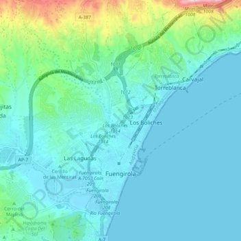
Name: Fuengirola topographic map, elevation, terrain.

Location: Fuengirola, Costa del Sol Occidental, Malaga, Andalusia, Spain (36.51902 -4.63662 36.58969 -4.58984)

Average elevation: 194 ft

Minimum elevation: -3 ft

Maximum elevation: 1,214 ft

Other topographic maps

Click on a map to view its topography, its elevation and its terrain.

Sierra Bermeja

Spain > Andalusia > Costa del Sol Occidental > Casares

Average elevation: 3,556 ft

Artola

Spain > Andalusia > Costa del Sol Occidental > Marbella

Average elevation: 180 ft

Mijas Golf

Spain > Andalusia > Costa del Sol Occidental

Average elevation: 190 ft

Madrid

Spain > Andalusia > Costa del Sol Occidental > Casares

Average elevation: 2,418 ft

Chaparral

Spain > Andalusia > Costa del Sol Occidental

Average elevation: 95 ft

Campo-Mijas

Spain > Andalusia > Costa del Sol Occidental

Average elevation: 171 ft

Campo-Mijas

Spain > Andalusia > Costa del Sol Occidental

Average elevation: 171 ft

Entrerríos

Spain > Andalusia > Costa del Sol Occidental

Average elevation: 397 ft

Bel-Air

Spain > Andalusia > Costa del Sol Occidental > Estepona

Average elevation: 115 ft

La Concha

Spain > Andalusia > Costa del Sol Occidental > Marbella

Average elevation: 2,572 ft

Rícmar

Spain > Andalusia > Costa del Sol Occidental > Marbella

Average elevation: 115 ft

Gear up for your next adventure:

🦶Carbon Trekking Poles - Reduce knee impact on steep descents with ultra-light poles
Backpacking Tent - Lightweight and durable tent for multi‑day hikes
Backpacking Tents - Weight-optimized shelters for multi-day topographic surveys
🚑Emergency Bivvies - Heat-reflective sleeping bags for survival situations
🩹Survival Bandages - High‑quality bandages for emergencies

As an Amazon Associate, this site earns from qualifying purchases at no extra cost to you.