Geolocate

Argyll topographic map

Click on the map to display elevation.

About this map

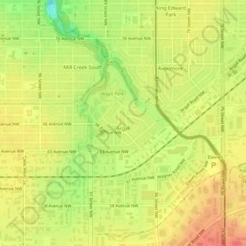
Name: Argyll topographic map, elevation, terrain.

Location: Argyll, Mill Creek South, Edmonton, Alberta, Canada (53.49988 -113.46687 53.50603 -113.45372)

Average elevation: 2,211 ft

Minimum elevation: 2,110 ft

Maximum elevation: 2,270 ft

Other topographic maps

Click on a map to view its topography, its elevation and its terrain.

landslide

Canada > Alberta > Edmonton

Average elevation: 2,192 ft

William Hawrelak Park

Canada > Alberta > Edmonton

Average elevation: 2,129 ft

Horseshoe Lake

Canada > Alberta > Edmonton

Average elevation: 2,231 ft

Ormsby Park

Canada > Alberta > Edmonton

Average elevation: 2,257 ft

Gear up for your next adventure:

🔋Solar Power Banks - Keep your GPS and phone charged in remote wilderness areas
🌡️Portable Weather Meter - Track weather conditions on the trail
🪑Portable Camp Table - Compact table for campsite meals
🪶Camp Gear Gift Set - Perfect gift bundle for outdoor fans
📷Action Camera - Capture your outdoor adventures in HD

As an Amazon Associate, this site earns from qualifying purchases at no extra cost to you.