Geolocate

Nilakantha topographic map

Click on the map to display elevation.

About this map
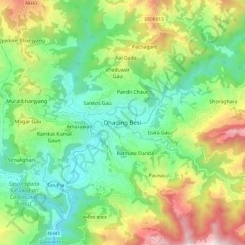
Name: Nilakantha topographic map, elevation, terrain.

Location: Nilakantha, Dhading, Bagamati Province, Nepal (27.87089 84.85528 27.95089 84.93528)

Average elevation: 2,864 ft

Minimum elevation: 1,617 ft

Maximum elevation: 5,213 ft

Other topographic maps

Click on a map to view its topography, its elevation and its terrain.

Galchhi

Nepal > Bagamati Province > Dhading

Average elevation: 3,136 ft

Galchhi

Nepal > Bagamati Province > Dhading

Average elevation: 3,136 ft

Gajuri

Nepal > Bagamati Province > Dhading

Average elevation: 3,504 ft

Dhunibesi

Nepal > Bagamati Province > Dhading

Average elevation: 4,590 ft

Nilakantha

Nepal > Bagamati Province > Dhading

Average elevation: 3,363 ft

Netrawati Dabjong

Nepal > Bagamati Province > Dhading

Average elevation: 3,842 ft

Gangajamuna

Nepal > Bagamati Province > Dhading

Average elevation: 4,961 ft

Gear up for your next adventure:

🪶Trail Camera - Capture wildlife on your hikes
🏔️Mountain Trail Maps - High‑detail maps for popular peaks
🧣Merino Neck Gaiters - Multi-functional headwear for wind and sun protection
🌡️Handheld Weather Meters - Measure wind, temp, and pressure for safe mountain travel
🪑Portable Camp Table - Compact table for campsite meals

As an Amazon Associate, this site earns from qualifying purchases at no extra cost to you.