Geolocate

Bowler topographic map

Click on the map to display elevation.

About this map

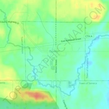
Name: Bowler topographic map, elevation, terrain.

Location: Bowler, Shawano County, Wisconsin, United States (44.85400 -88.99360 44.87038 -88.97130)

Average elevation: 1,086 ft

Minimum elevation: 1,030 ft

Maximum elevation: 1,181 ft

Shawano County trails, hiking, mountain biking, running and outdoor activities

Other topographic maps

Click on a map to view its topography, its elevation and its terrain.

Pittsfield

United States > Wisconsin > Shawano County

Average elevation: 804 ft

Pella

United States > Wisconsin > Shawano County

Average elevation: 922 ft

Caroline

United States > Wisconsin > Shawano County

Average elevation: 988 ft

Gear up for your next adventure:

🔦Compact Flashlight - Reliable flashlight for emergencies
🏕️Tent Footprint - Protect your tent base from wear
🪶Thermal Camp Blanket - Extra warmth for cold nights
📡Handheld GPS Device - Reliable handheld GPS for outdoor navigation
📚Navigation Handbooks - Master the art of reading topographic maps and using a compass

As an Amazon Associate, this site earns from qualifying purchases at no extra cost to you.