
Make a donation
Gear up for your next adventure:
As an Amazon Associate, this site earns from qualifying purchases at no extra cost to you.
Sanaag topographic map
Click on the map to display elevation.
Make a donation
Gear up for your next adventure:
As an Amazon Associate, this site earns from qualifying purchases at no extra cost to you.
About this map
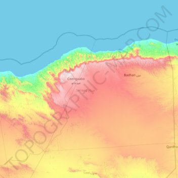
Name: Sanaag topographic map, elevation, terrain.
Location: Sanaag, Somaliland, Somalia (9.42002 46.01003 11.52611 49.06000)
Average elevation: 2,037 ft
Minimum elevation: 0 ft
Maximum elevation: 7,848 ft
Make a donation
Gear up for your next adventure:
As an Amazon Associate, this site earns from qualifying purchases at no extra cost to you.
Other topographic maps
Click on a map to view its topography, its elevation and its terrain.
Hargeisa
Somaliland > Woqooyi Galbeed > Hargeisa District
Hargeisa is situated in a valley in the Galgodon (Ogo) highlands, and sits at an elevation of 1,334 m (4,377 ft). Home to rock art from the Neolithic period, the city is also a commercial hub for precious stone-cutting, construction, retail services and trading, among other activities.
Average elevation: 4,229 ft
Make a donation
Gear up for your next adventure:
As an Amazon Associate, this site earns from qualifying purchases at no extra cost to you.
Make a donation
Gear up for your next adventure:
As an Amazon Associate, this site earns from qualifying purchases at no extra cost to you.
Make a donation
Gear up for your next adventure:
As an Amazon Associate, this site earns from qualifying purchases at no extra cost to you.
Hargeisa
Somaliland > Woqooyi Galbeed > Hargeisa District
Hargeisa is situated in a valley in the Galgodon (Ogo) highlands, and sits at an elevation of 1,334 m (4,377 ft). Home to rock art from the Neolithic period, the city is also a commercial hub for precious stone-cutting, construction, retail services and trading, among other activities.
Average elevation: 4,229 ft
Erigavo
Somaliland > Sanaag > Erigavo District
10 kilometres or 6.2 miles to the north of the town are remnant juniper woodlands that form part of the northern escarpment forests fringing the Sanaag highlands, within the Somali montane xeric woodlands ecoregion. The escarpment forms a sharp drop to the Gulf of Aden coastal plain, reaching around 2,000…
Average elevation: 5,820 ft
Make a donation
Gear up for your next adventure:
As an Amazon Associate, this site earns from qualifying purchases at no extra cost to you.
Make a donation
Gear up for your next adventure:
As an Amazon Associate, this site earns from qualifying purchases at no extra cost to you.
Make a donation
Gear up for your next adventure:
As an Amazon Associate, this site earns from qualifying purchases at no extra cost to you.
Make a donation
Gear up for your next adventure:
As an Amazon Associate, this site earns from qualifying purchases at no extra cost to you.
Burao
Somaliland > Togdheer > Burao District
Weather in Burao, much like other inland towns in Somaliland, is very warm to hot and dry year-round. The city has a hot arid climate (Köppen BWh) in common with most of Somalia, although Burao's weather is moderated by altitude. The average daytime temperatures during the summer months of June and August can…
Average elevation: 3,448 ft
Make a donation
Gear up for your next adventure:
As an Amazon Associate, this site earns from qualifying purchases at no extra cost to you.
Make a donation
Gear up for your next adventure:
As an Amazon Associate, this site earns from qualifying purchases at no extra cost to you.
Make a donation
Gear up for your next adventure:
As an Amazon Associate, this site earns from qualifying purchases at no extra cost to you.
Make a donation
Gear up for your next adventure:
As an Amazon Associate, this site earns from qualifying purchases at no extra cost to you.