Geolocate

Mount Sharp topographic map

Click on the map to display elevation.

About this map

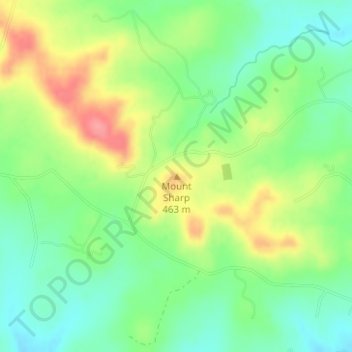
Name: Mount Sharp topographic map, elevation, terrain.

Location: Mount Sharp, Hays County, Texas, United States (30.10016 -98.21229 30.10026 -98.21219)

Average elevation: 1,407 ft

Minimum elevation: 1,293 ft

Maximum elevation: 1,578 ft

Hays County trails, hiking, mountain biking, running and outdoor activities

Other topographic maps

Click on a map to view its topography, its elevation and its terrain.

Hays

United States > Texas > Hays County

Average elevation: 771 ft

Niederwald

United States > Texas > Hays County

Average elevation: 597 ft

Bear Creek

United States > Texas > Hays County

Average elevation: 978 ft

Sewell Park

United States > Texas > Hays County > San Marcos

Average elevation: 630 ft

Gear up for your next adventure:

📷Action Camera - Capture your outdoor adventures in HD
🚁Photography Drones - Capture stunning aerial views of landforms and topography
Backpacking Tents - Weight-optimized shelters for multi-day topographic surveys
🧭Map Reading Tools - Tools and kits for map navigation
🎒Waterproof Dry Bags - Keep your electronics and maps dry inside your pack

As an Amazon Associate, this site earns from qualifying purchases at no extra cost to you.