Geolocate

Hays topographic map

Click on the map to display elevation.

About this map

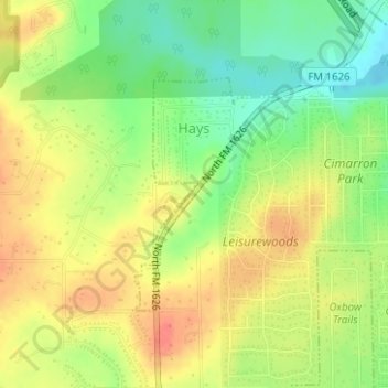
Name: Hays topographic map, elevation, terrain.

Location: Hays, Hays County, Texas, United States (30.10997 -97.87717 30.12621 -97.86541)

Average elevation: 771 ft

Minimum elevation: 673 ft

Maximum elevation: 856 ft

Hays County trails, hiking, mountain biking, running and outdoor activities

Other topographic maps

Click on a map to view its topography, its elevation and its terrain.

Goforth

United States > Texas > Hays County

Average elevation: 627 ft

Wimberley

United States > Texas > Hays County > Wimberley > Wimberley

Average elevation: 988 ft

Mount Gainor

United States > Texas > Hays County

Average elevation: 1,224 ft

Kyle

United States > Texas > Hays County

Average elevation: 709 ft

Pioneer Town

United States > Texas > Hays County > Wimberley

Average elevation: 932 ft

Sewell Park

United States > Texas > Hays County > San Marcos

Average elevation: 630 ft

Kyle

United States > Texas > Hays County > Kyle

Average elevation: 709 ft

Mount Sharp

United States > Texas > Hays County

Average elevation: 1,407 ft

Gear up for your next adventure:

🧥Men's Rain Shells - Premium waterproof and breathable jackets for mountain weather
🥤Water Filter Bottle - All‑in‑one filter bottle for safe hydration
📡Handheld GPS Device - Reliable handheld GPS for outdoor navigation
🔪Outdoor Multitools - Essential survival tools for gear repair and field use
🌎3D Topographic Globes - Raised relief globes for a tactile understanding of geography

As an Amazon Associate, this site earns from qualifying purchases at no extra cost to you.