
Make a donation
Gear up for your next adventure:
As an Amazon Associate, this site earns from qualifying purchases at no extra cost to you.
Gauseköte topographic map
Click on the map to display elevation.
Make a donation
Gear up for your next adventure:
As an Amazon Associate, this site earns from qualifying purchases at no extra cost to you.
Gauseköte
Die Passhöhe liegt im Wald des Forst Berlebeck knapp 2,5 km (Luftlinie) westlich des Oberen Langenbergs (418,8 m) mit westlich vorgelagertem Unterem Langenberg (ca. 410 m). Etwa 500 m nordnordwestlich von ihr befindet sich der Große Gauseköterberg (366,7 m) und etwa 1,7 km nordnordöstlich die Ruine Falkenburg (372,6 m). Etwa 800 m nordwestlich der Passhöhe verläuft in Nordnordost-Südsüdwest-Richtung der die eingangs genannten Ortsteile verbindende Alte Postweg.
Make a donation
Gear up for your next adventure:
As an Amazon Associate, this site earns from qualifying purchases at no extra cost to you.
About this map
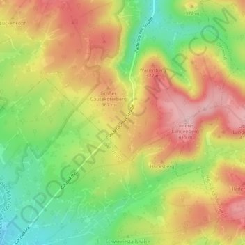
Name: Gauseköte topographic map, elevation, terrain.
Average elevation: 1,086 ft
Minimum elevation: 761 ft
Maximum elevation: 1,381 ft
Make a donation
Gear up for your next adventure:
As an Amazon Associate, this site earns from qualifying purchases at no extra cost to you.
Other topographic maps
Click on a map to view its topography, its elevation and its terrain.
Berlebeck
Deutschland > Nordrhein-Westfalen > Kreis Lippe > Detmold > Berlebeck
Average elevation: 971 ft