
Make a donation
Gear up for your next adventure:
As an Amazon Associate, this site earns from qualifying purchases at no extra cost to you.
Berlebeck topographic map
Click on the map to display elevation.
Make a donation
Gear up for your next adventure:
As an Amazon Associate, this site earns from qualifying purchases at no extra cost to you.
About this map
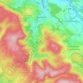
Name: Berlebeck topographic map, elevation, terrain.
Average elevation: 971 ft
Minimum elevation: 551 ft
Maximum elevation: 1,401 ft
Make a donation
Gear up for your next adventure:
As an Amazon Associate, this site earns from qualifying purchases at no extra cost to you.
Other topographic maps
Click on a map to view its topography, its elevation and its terrain.
Gauseköte
Deutschland > Nordrhein-Westfalen > Kreis Lippe > Detmold > Berlebeck
Die Passhöhe liegt im Wald des Forst Berlebeck knapp 2,5 km (Luftlinie) westlich des Oberen Langenbergs (418,8 m) mit westlich vorgelagertem Unterem Langenberg (ca. 410 m). Etwa 500 m nordnordwestlich von ihr befindet sich der Große Gauseköterberg (366,7 m) und etwa 1,7 km nordnordöstlich die Ruine…
Average elevation: 1,086 ft