
Mirandela topographic map
Interactive map
Click on the map to display elevation.
About this map
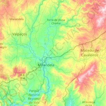
Name: Mirandela topographic map, elevation, terrain.
Location: Mirandela, Bragança, Portugal (41.33369 -7.36686 41.73523 -7.02919)
Average elevation: 1,693 ft
Minimum elevation: 558 ft
Maximum elevation: 4,124 ft
Other topographic maps
Click on a map to view its topography, its elevation and its terrain.
Penhas Juntas
Penhas Juntas, Vinhais, Bragança, Portugal
Average elevation: 2,346 ft
Montesinho Nature Park
Portugal > Bragança > Bragança > Espinhosela
Montesinho Nature Park, Espinhosela, Bragança, 5300-245, Portugal
Average elevation: 2,890 ft
Carrazeda de Ansiães
Carrazeda de Ansiães, Bragança, Portugal
Average elevation: 1,765 ft
Macedo de Cavaleiros
Portugal > Bragança > Macedo de Cavaleiros
Macedo de Cavaleiros, Bragança, Portugal
Average elevation: 1,949 ft
Mua
Portugal > Bragança > Torre de Moncorvo
Mua, Torre de Moncorvo, Bragança, Portugal
Average elevation: 2,280 ft