
Make a donation
Gear up for your next adventure:
As an Amazon Associate, this site earns from qualifying purchases at no extra cost to you.
Wessingen topographic map
Click on the map to display elevation.
Make a donation
Gear up for your next adventure:
As an Amazon Associate, this site earns from qualifying purchases at no extra cost to you.
About this map
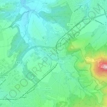
Name: Wessingen topographic map, elevation, terrain.
Average elevation: 1,844 ft
Minimum elevation: 1,558 ft
Maximum elevation: 2,769 ft
Make a donation
Gear up for your next adventure:
As an Amazon Associate, this site earns from qualifying purchases at no extra cost to you.
Other topographic maps
Click on a map to view its topography, its elevation and its terrain.
Hohenzollern Castle
Germany > Baden-Württemberg > Zollernalbkreis > Bisingen
Average elevation: 2,073 ft
Rosenfeld
Germany > Baden-Württemberg > Zollernalbkreis > Rosenfeld > Isingen
Average elevation: 1,965 ft
Burladingen
Germany > Baden-Württemberg > Zollernalbkreis
The township (Stadt) of Burladingen is located in the Swabian Jura, specifically where the Middle Kuppenalb [de] transitions into the western Jura. Elevation above sea level in the municipal area varies from a low of 611 meters (2,005 ft) Normalnull (NN) to a high of 933 meters (3,061 ft).
Average elevation: 2,572 ft
Make a donation
Gear up for your next adventure:
As an Amazon Associate, this site earns from qualifying purchases at no extra cost to you.
Meßstetten
Germany > Baden-Württemberg > Zollernalbkreis
Meßstetten (German: [mɛsˈʃtɛtn] ) is a town in the Zollernalbkreis district, in Baden-Württemberg, Germany, which is situated in the Swabian Jura, 24 km southeast of Balingen. At an altitude of 907 m (2,976 ft), Meßstetten is the highest city (of more than 10,000 inhabitants) in Germany. It is close to…
Average elevation: 2,828 ft
Dormettingen
Germany > Baden-Württemberg > Zollernalbkreis
The municipality (Gemeinde) of Dormettingen covers 6.55 square kilometers (2.53 sq mi) of the Zollernalb district of Baden-Württemberg, one of the Federal Republic of Germany's 16 States. It is physically located on the Little Heuberg [de], a plateau above the Schlichem where oil shale can be found in the…
Average elevation: 2,103 ft
Make a donation
Gear up for your next adventure:
As an Amazon Associate, this site earns from qualifying purchases at no extra cost to you.
Albstadt
Germany > Baden-Württemberg > Zollernalbkreis
Albstadt is spread across a variety of hills and valleys, its elevation ranges between 614 m (2,014 ft) above sea level and 966 m (3,169 ft). One valley is the river Schmiecha, a left-hand tributary of the Danube, a second valley is the river of upper Eyach, a tributary of the Neckar.
Average elevation: 2,671 ft
Schömberg (Stadt)
Germany > Baden-Württemberg > Zollernalbkreis
The township (Stadt) of Schömberg is located in Zollernalbkreis, a district of the German state of Baden-Württemberg. It is physically located in the foothills of the Swabian Jura, specifically in the Upper Swabian Jura [de]. The main watercourse in the municipal area is the Schlichem, whose deeply-cut…
Average elevation: 2,244 ft
Make a donation
Gear up for your next adventure:
As an Amazon Associate, this site earns from qualifying purchases at no extra cost to you.