
Make a donation
Gear up for your next adventure:
As an Amazon Associate, this site earns from qualifying purchases at no extra cost to you.
Éghezée topographic map
Click on the map to display elevation.
Make a donation
Gear up for your next adventure:
As an Amazon Associate, this site earns from qualifying purchases at no extra cost to you.
Éghezée
Éghezée, dikwijls geschreven als Eghezée, is een plaats en gemeente in de Belgische provincie Namen, in het uiterste noorden hiervan. De gemeente telt ruim 16.000 inwoners en ligt op een hoogte van 154 meter.
Make a donation
Gear up for your next adventure:
As an Amazon Associate, this site earns from qualifying purchases at no extra cost to you.
About this map
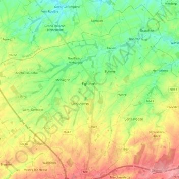
Name: Éghezée topographic map, elevation, terrain.
Location: Éghezée, Namen, Wallonië, 5310, België (50.52594 4.78703 50.64844 4.98978)
Average elevation: 522 ft
Minimum elevation: 394 ft
Maximum elevation: 699 ft
Make a donation
Gear up for your next adventure:
As an Amazon Associate, this site earns from qualifying purchases at no extra cost to you.
Other topographic maps
Click on a map to view its topography, its elevation and its terrain.
Make a donation
Gear up for your next adventure:
As an Amazon Associate, this site earns from qualifying purchases at no extra cost to you.