Geolocate

Bulsa topographic map

Click on the map to display elevation.

About this map

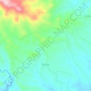
Name: Bulsa topographic map, elevation, terrain.

Location: Bulsa, San Juan, Batangas, Calabarzon, Philippines (13.69432 121.37951 13.72761 121.41494)

Average elevation: 315 ft

Minimum elevation: 102 ft

Maximum elevation: 935 ft

Other topographic maps

Click on a map to view its topography, its elevation and its terrain.

Malaking Tubig River

Philippines > Batangas > San Juan

Average elevation: 33 ft

Ticalan

Philippines > Batangas > San Juan > Ticalan

Average elevation: 26 ft

Hugom

Philippines > Batangas > San Juan > Hugom

Average elevation: 249 ft

Gear up for your next adventure:

🎒Outdoor Daypacks - Lightweight backpacks designed for carrying maps and essential gear
🚪Portable Camp Chair - Foldable chair for comfort at camp
📚Navigation Handbooks - Master the art of reading topographic maps and using a compass
🪶Fire Starter Kit - Reliable fire starter for survival and camping
🪶Multi‑Purpose Knife - Useful blade for camp and trail

As an Amazon Associate, this site earns from qualifying purchases at no extra cost to you.