Geolocate

Falcon Heights topographic map

Click on the map to display elevation.

About this map

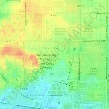
Name: Falcon Heights topographic map, elevation, terrain.

Location: Falcon Heights, Ramsey County, Minnesota, United States (44.97722 -93.19738 44.99904 -93.15656)

Average elevation: 955 ft

Minimum elevation: 889 ft

Maximum elevation: 1,017 ft

Ramsey County trails, hiking, mountain biking, running and outdoor activities

Other topographic maps

Click on a map to view its topography, its elevation and its terrain.

Como Lake

United States > Minnesota > Ramsey County > Saint Paul

Average elevation: 919 ft

Crosby Lake

United States > Minnesota > Ramsey County > Saint Paul

Average elevation: 797 ft

Midvale

United States > Minnesota > Ramsey County > Maplewood

Average elevation: 1,001 ft

Gladstone

United States > Minnesota > Ramsey County > Maplewood

Average elevation: 935 ft

Gear up for your next adventure:

🗺️NatGeo Topo Maps - High-quality waterproof printed topographic maps of US Parks
👟Trail Running Shoes - Lightweight shoes for trail runners
🗻Climbing Gear Basics - Essential gear for beginner climbers
🪶Trail Camera - Capture wildlife on your hikes
🪶Compact Camp Shovel - Folding shovel for campsite tasks

As an Amazon Associate, this site earns from qualifying purchases at no extra cost to you.