Geolocate

Walker topographic map

Click on the map to display elevation.

About this map

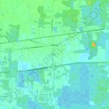
Name: Walker topographic map, elevation, terrain.

Location: Walker, Livingston Parish, Louisiana, United States (30.45407 -90.89881 30.50609 -90.79350)

Average elevation: 39 ft

Minimum elevation: 13 ft

Maximum elevation: 131 ft

Livingston Parish trails, hiking, mountain biking, running and outdoor activities

Other topographic maps

Click on a map to view its topography, its elevation and its terrain.

Holden

United States > Louisiana > Livingston Parish

Average elevation: 36 ft

Watson

United States > Louisiana > Livingston Parish

Average elevation: 69 ft

Satsuma

United States > Louisiana > Livingston Parish

Average elevation: 36 ft

Lockhart

United States > Louisiana > Livingston Parish

Average elevation: 46 ft

Gear up for your next adventure:

🛶Inflatable Kayak - Portable kayak for rivers, lakes, and expeditions
🛠️Outdoor Gear Repair Kit - Essential tools to fix gear on the trail
🔦Powerful Headlamps - Ultra-bright hands-free lighting for night navigation
🪶Trail Camera - Capture wildlife on your hikes
🍳Camping Cook Set - Complete cookware for outdoor meals

As an Amazon Associate, this site earns from qualifying purchases at no extra cost to you.