Geolocate

Satsuma topographic map

Click on the map to display elevation.

About this map

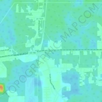
Name: Satsuma topographic map, elevation, terrain.

Location: Satsuma, Livingston Parish, Louisiana, United States (30.48269 -90.82038 30.52269 -90.78038)

Average elevation: 36 ft

Minimum elevation: 13 ft

Maximum elevation: 135 ft

Other topographic maps

Click on a map to view its topography, its elevation and its terrain.

Walker

United States > Louisiana > Livingston Parish

Average elevation: 39 ft

Albany

United States > Louisiana > Livingston Parish

Average elevation: 39 ft

Albany

United States > Louisiana > Livingston Parish

Average elevation: 39 ft

Killian

United States > Louisiana > Livingston Parish

Average elevation: 13 ft

Gear up for your next adventure:

🕶️GPS Smartphone Mount - Secure mount for phone navigation
📶Vehicle Signal Boosters - Improve reception in rural areas while driving to trailheads
🦶Carbon Trekking Poles - Reduce knee impact on steep descents with ultra-light poles
👓Polarized Sunglasses - Outdoor sunglasses for glare reduction
🖼️Topo Map Wall Art - Decorative topographic prints of famous peaks and regions

As an Amazon Associate, this site earns from qualifying purchases at no extra cost to you.