
Make a donation
Gear up for your next adventure:
As an Amazon Associate, this site earns from qualifying purchases at no extra cost to you.
Badlands Rock topographic map
Click on the map to display elevation.
Make a donation
Gear up for your next adventure:
As an Amazon Associate, this site earns from qualifying purchases at no extra cost to you.
About this map
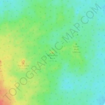
Name: Badlands Rock topographic map, elevation, terrain.
Location: Badlands Rock, Deschutes County, Oregon, United States (43.99157 -121.02809 43.99167 -121.02799)
Average elevation: 3,576 ft
Minimum elevation: 3,510 ft
Maximum elevation: 3,694 ft
Deschutes County trails, hiking, mountain biking, running and outdoor activities
Make a donation
Gear up for your next adventure:
As an Amazon Associate, this site earns from qualifying purchases at no extra cost to you.
Other topographic maps
Click on a map to view its topography, its elevation and its terrain.
Archie Briggs Canyon Natural Area
United States > Oregon > Deschutes County > Bend
Average elevation: 3,658 ft
Make a donation
Gear up for your next adventure:
As an Amazon Associate, this site earns from qualifying purchases at no extra cost to you.
Smith Rock State Park
United States > Oregon > Deschutes County > Terrebonne
Average elevation: 2,871 ft