
Make a donation
Gear up for your next adventure:
As an Amazon Associate, this site earns from qualifying purchases at no extra cost to you.
Deschutes River Woods topographic map
Click on the map to display elevation.
Make a donation
Gear up for your next adventure:
As an Amazon Associate, this site earns from qualifying purchases at no extra cost to you.
About this map
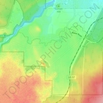
Name: Deschutes River Woods topographic map, elevation, terrain.
Average elevation: 3,970 ft
Minimum elevation: 3,802 ft
Maximum elevation: 4,193 ft
Deschutes County trails, hiking, mountain biking, running and outdoor activities
Make a donation
Gear up for your next adventure:
As an Amazon Associate, this site earns from qualifying purchases at no extra cost to you.
Other topographic maps
Click on a map to view its topography, its elevation and its terrain.
Archie Briggs Canyon Natural Area
United States > Oregon > Deschutes County > Bend
Average elevation: 3,658 ft
Make a donation
Gear up for your next adventure:
As an Amazon Associate, this site earns from qualifying purchases at no extra cost to you.
Smith Rock State Park
United States > Oregon > Deschutes County > Terrebonne
Average elevation: 2,871 ft
Three Sisters
United States > Oregon > Deschutes County
The Three Sisters are closely spaced volcanic peaks in the U.S. state of Oregon. They are part of the Cascade Volcanic Arc, a segment of the Cascade Range in western North America extending from southern British Columbia through Washington and Oregon to Northern California. Each more than 10,000 feet (3,000 m)…
Average elevation: 8,287 ft
Make a donation
Gear up for your next adventure:
As an Amazon Associate, this site earns from qualifying purchases at no extra cost to you.