
Silverton topographic map
Click on the map to display elevation.
Silverton
According to the United States Census Bureau, the town has a total area of 0.8 square miles (2.1 km2), all of it land. Silverton is one of the highest towns in the United States, at 9,318 feet (2,840 m) above sea level. The town is located in San Juan County, the highest county in the United States, with a mean elevation of 11,240 feet (3,430 meters). Silverton sits in a flat area of the Animas River valley and is surrounded by several thirteeners, the highest being Storm Peak, at 13,487 feet. The town is less than 15 miles from seven of Colorado's 53 "fourteeners", i.e., mountain peaks with a summit elevation of at least 14,000 feet (4,300 meters).
About this map
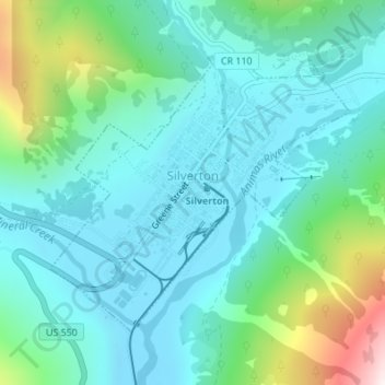
Name: Silverton topographic map, elevation, terrain.
Location: Silverton, San Juan County, Colorado, 81433, United States (37.80055 -107.67702 37.82005 -107.65038)
Average elevation: 9,813 ft
Minimum elevation: 9,222 ft
Maximum elevation: 12,011 ft
San Juan County trails, hiking, mountain biking, running and outdoor activities
Other topographic maps
Click on a map to view its topography, its elevation and its terrain.
Animas Forks
United States > Colorado > San Juan County
Animas Forks is located on a system of roads known as the Alpine Loop. The loop is a 65-mile (105 km) system of unpaved roads which connects the small mountain towns of Lake City, Ouray, and Silverton. Most of the land in the area is managed by either the U.S. Forest Service or the Bureau of Land Management.…
Average elevation: 11,929 ft
Tower Mountain
United States > Colorado > San Juan County
Tower Mountain, elevation 13,558 ft (4,132 m), is a summit located northeast of Silverton, Colorado.
Average elevation: 12,395 ft