
Make a donation
Gear up for your next adventure:
As an Amazon Associate, this site earns from qualifying purchases at no extra cost to you.
Embreeville Mountain topographic map
Click on the map to display elevation.
Make a donation
Gear up for your next adventure:
As an Amazon Associate, this site earns from qualifying purchases at no extra cost to you.
About this map
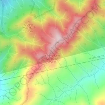
Name: Embreeville Mountain topographic map, elevation, terrain.
Average elevation: 2,192 ft
Minimum elevation: 1,604 ft
Maximum elevation: 2,844 ft
Washington County trails, hiking, mountain biking, running and outdoor activities
Make a donation
Gear up for your next adventure:
As an Amazon Associate, this site earns from qualifying purchases at no extra cost to you.
Other topographic maps
Click on a map to view its topography, its elevation and its terrain.
Johnson City
United States > Tennessee > Washington County
The steep mountains, rolling hills, and valleys surrounding the region are part of the Appalachian Ridge-and-Valley Province, and Johnson City is just west of the Blue Ridge Mountains. Roan Mountain, with an elevation of over 6,000 feet (1,800 m), is approximately 20 miles (32 km) to the southeast of the city.…
Average elevation: 1,683 ft
Make a donation
Gear up for your next adventure:
As an Amazon Associate, this site earns from qualifying purchases at no extra cost to you.
Johnson City
United States > Tennessee > Washington County
Johnson City has a humid subtropical climate (Köppen Cfa), with warm summers and cool winters. Temperatures in Johnson City are moderated somewhat by its elevation and proximity to the Appalachian Mountains. Precipitation is abundant, with an average of 45.22 in (1,149 mm). Summer is typically the wettest…
Average elevation: 1,683 ft