Geolocate

Großheide topographic map

Click on the map to display elevation.

About this map

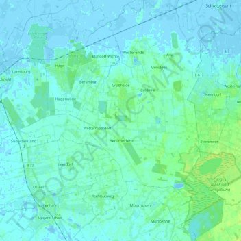
Name: Großheide topographic map, elevation, terrain.

Location: Großheide, Landkreis Aurich, Lower Saxony, 26532, Germany (53.50251 7.30105 53.64085 7.44331)

Average elevation: 10 ft

Minimum elevation: -13 ft

Maximum elevation: 36 ft

Other topographic maps

Click on a map to view its topography, its elevation and its terrain.

Arle

Germany > Lower Saxony > Landkreis Aurich > Großheide

Average elevation: 7 ft

Arle

Germany > Lower Saxony > Landkreis Aurich > Großheide

Average elevation: 7 ft

Greetsiel

Germany > Lower Saxony > Landkreis Aurich

Average elevation: -3 ft

Gear up for your next adventure:

🔋Rechargeable Batteries - Power up your outdoor devices
GPS Sports Watch - GPS watch for running, hiking and training
🗻Climbing Gear Basics - Essential gear for beginner climbers
🪶Camp Gear Gift Set - Perfect gift bundle for outdoor fans
👓Polarized Sunglasses - Outdoor sunglasses for glare reduction

As an Amazon Associate, this site earns from qualifying purchases at no extra cost to you.