
Make a donation
Gear up for your next adventure:
As an Amazon Associate, this site earns from qualifying purchases at no extra cost to you.
Oberdrees topographic map
Click on the map to display elevation.
Make a donation
Gear up for your next adventure:
As an Amazon Associate, this site earns from qualifying purchases at no extra cost to you.
Oberdrees
Karnevalistischer Höhepunkt in Oberdrees ist der Straßenkarneval, der hier auf eine ca. 100-jährige Tradition zurückblicken kann. Ein Alleinstellungsmerkmal nimmt aber ohne Zweifel der mit dem Karneval verbundene Bau von Fest- und Umzugs-Wagen jeder Art und Größe ein. Neben dem Festumzug, der immer am Fastnachtssonntag stattfindet, nehmen Oberdreeser Jacken, wie beispielsweise der Karnevalsgemeinschaft Oberdrees von 1926 e. V., namens: „Bekömme Dich net drömm!“, auch an den Festivitäten der Kernstadt Rheinbach teil.
Make a donation
Gear up for your next adventure:
As an Amazon Associate, this site earns from qualifying purchases at no extra cost to you.
About this map
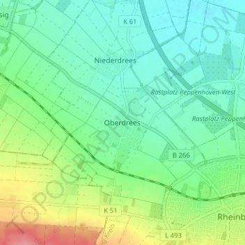
Name: Oberdrees topographic map, elevation, terrain.
Average elevation: 554 ft
Minimum elevation: 469 ft
Maximum elevation: 755 ft
Make a donation
Gear up for your next adventure:
As an Amazon Associate, this site earns from qualifying purchases at no extra cost to you.
Other topographic maps
Click on a map to view its topography, its elevation and its terrain.
Wormersdorf
Deutschland > Nordrhein-Westfalen > Rhein-Sieg-Kreis > Rheinbach
Average elevation: 696 ft
Make a donation
Gear up for your next adventure:
As an Amazon Associate, this site earns from qualifying purchases at no extra cost to you.