
Make a donation
Gear up for your next adventure:
As an Amazon Associate, this site earns from qualifying purchases at no extra cost to you.
Wormersdorf topographic map
Click on the map to display elevation.
Make a donation
Gear up for your next adventure:
As an Amazon Associate, this site earns from qualifying purchases at no extra cost to you.
About this map
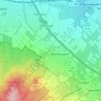
Name: Wormersdorf topographic map, elevation, terrain.
Average elevation: 696 ft
Minimum elevation: 538 ft
Maximum elevation: 1,093 ft
Make a donation
Gear up for your next adventure:
As an Amazon Associate, this site earns from qualifying purchases at no extra cost to you.
Other topographic maps
Click on a map to view its topography, its elevation and its terrain.
Oberdrees
Deutschland > Nordrhein-Westfalen > Rhein-Sieg-Kreis > Rheinbach
Karnevalistischer Höhepunkt in Oberdrees ist der Straßenkarneval, der hier auf eine ca. 100-jährige Tradition zurückblicken kann. Ein Alleinstellungsmerkmal nimmt aber ohne Zweifel der mit dem Karneval verbundene Bau von Fest- und Umzugs-Wagen jeder Art und Größe ein. Neben dem Festumzug, der immer am…
Average elevation: 554 ft
Todenfeld
Deutschland > Nordrhein-Westfalen > Rhein-Sieg-Kreis > Rheinbach
Der Ort liegt rund 6 km südlich der Rheinbacher Kernstadt an der L492 auf den Höhen der nördlichen Eifel im Ahrgebirge unmittelbar an der Landesgrenze zu Rheinland-Pfalz. Nachbarorte sind im Südosten Bad Neuenahr-Ahrweiler, Südwesten Bad Münstereifel, Nordwesten Euskirchen und Nordosten Meckenheim. Die…
Average elevation: 1,099 ft
Make a donation
Gear up for your next adventure:
As an Amazon Associate, this site earns from qualifying purchases at no extra cost to you.
Ipplendorf
Deutschland > Nordrhein-Westfalen > Rhein-Sieg-Kreis > Rheinbach > Ipplendorf
Average elevation: 735 ft
Hardt
Deutschland > Nordrhein-Westfalen > Rhein-Sieg-Kreis > Rheinbach > Loch
Average elevation: 1,014 ft