
Garvagh topographic map
Click on the map to display elevation.
About this map
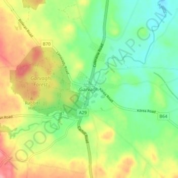
Name: Garvagh topographic map, elevation, terrain.
Average elevation: 305 ft
Minimum elevation: 157 ft
Maximum elevation: 518 ft
Other topographic maps
Click on a map to view its topography, its elevation and its terrain.
Magilligan - Benone Strand
United Kingdom > Northern Ireland > County Londonderry > Castlerock > Downhill
Average elevation: 72 ft
Drumahoe
United Kingdom > Northern Ireland > County Londonderry > Derry/Londonderry
Average elevation: 151 ft
Causeway Coast and Glens District
United Kingdom > Northern Ireland > County Londonderry
Average elevation: 331 ft
Ballymagroarty
United Kingdom > Northern Ireland > County Londonderry > Derry/Londonderry
Average elevation: 240 ft
Mid-Ulster District Council
United Kingdom > Northern Ireland > County Londonderry
Average elevation: 367 ft
Foyle
United Kingdom > Northern Ireland > County Londonderry > Derry/Londonderry
Average elevation: 157 ft
Lough Foyle
United Kingdom > Northern Ireland > County Londonderry > Londonderry/Derry
Average elevation: 200 ft
Eglinton Registrars District
United Kingdom > Northern Ireland > County Londonderry > Greysteel
Average elevation: 285 ft
Foyle
United Kingdom > Northern Ireland > County Londonderry > Derry/Londonderry
Average elevation: 157 ft
Bay Road Park
United Kingdom > Northern Ireland > County Londonderry > Derry/Londonderry
Average elevation: 62 ft