Geolocate

Newcastle topographic map

Click on the map to display elevation.

Newcastle

In 1910 Harry Ferguson flew a small plane across Newcastle beach in one of the first engine powered flights by aircraft in Ireland. He completed the flight in an attempt to win a £100 prize offered by the town for the first powered flight along the strand. His first take off ended badly, but according to a modern newspaper report 'He flew a distance of almost three miles along the foreshore at a low altitude varying between fifty and five hundred feet'. This event is recorded by a plaque on the promenade.

Wikipedia (CC-BY-SA 3.0)

About this map

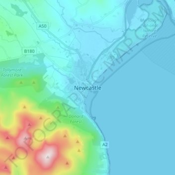
Name: Newcastle topographic map, elevation, terrain.

Location: Newcastle, Newry, Mourne and Down District Council, Northern Ireland, BT33 0AE, United Kingdom (54.17183 -5.92972 54.25183 -5.84972)

Average elevation: 377 ft

Minimum elevation: 0 ft

Maximum elevation: 2,766 ft

Other topographic maps

Click on a map to view its topography, its elevation and its terrain.

County Down

United Kingdom > Northern Ireland

Average elevation: 213 ft

Belfast

United Kingdom > Northern Ireland > County Antrim

Average elevation: 305 ft

Bann

United Kingdom > Northern Ireland

Average elevation: 348 ft

Strule

United Kingdom > Northern Ireland

Average elevation: 266 ft

Erne

United Kingdom > Northern Ireland

Average elevation: 381 ft

Sillees

United Kingdom > Northern Ireland

Average elevation: 213 ft

Boa Island

United Kingdom > Northern Ireland

Average elevation: 171 ft

Slaghtneill

United Kingdom > Northern Ireland

Average elevation: 630 ft

County Antrim

United Kingdom > Northern Ireland

A large portion of Antrim is hilly, especially in the east, where the highest elevations are attained. The range runs north and south, and, following this direction, the highest points are Knocklayd 514 m (1,690 ft), Slieveanorra 508 m (1,670 ft), Trostan 550 m (1,800 ft), Slemish 437 m (1,430 ft), Agnew's…

Average elevation: 230 ft

Snowhill

United Kingdom > Northern Ireland

Average elevation: 279 ft

Windyhill

United Kingdom > Northern Ireland

Average elevation: 404 ft

Drone

United Kingdom > Northern Ireland

Average elevation: 276 ft

Crom Castle

United Kingdom > Northern Ireland

Average elevation: 161 ft

Kilmore

United Kingdom > Northern Ireland

Average elevation: 108 ft

Quoile

United Kingdom > Northern Ireland > Downpatrick

Average elevation: 46 ft

Bush

United Kingdom > Northern Ireland > County Antrim > Bushmills

Average elevation: 118 ft

Arney River

United Kingdom > Northern Ireland > Arney

Average elevation: 177 ft

Tollymore

United Kingdom > Northern Ireland

Average elevation: 125 ft

Belfast

United Kingdom > Northern Ireland > County Antrim

Average elevation: 302 ft

Carrowclare

United Kingdom > Northern Ireland

Average elevation: 3 ft

Drumaroad

United Kingdom > Northern Ireland > Drumaroad

Average elevation: 407 ft

Belfast

United Kingdom > Northern Ireland > County Antrim

Average elevation: 305 ft

Castleward

United Kingdom > Northern Ireland

Average elevation: 98 ft

Holly-Hill

United Kingdom > Northern Ireland

Average elevation: 476 ft

Lecale Upper

United Kingdom > Northern Ireland > Dundrum

Average elevation: 82 ft

Bann

United Kingdom > Northern Ireland

Average elevation: 348 ft

Erne

United Kingdom > Northern Ireland

Average elevation: 381 ft

North Channel

United Kingdom > Northern Ireland

Average elevation: 171 ft

Ballynashee

United Kingdom > Northern Ireland

Average elevation: 676 ft

Carrowreagh

United Kingdom > Northern Ireland

Average elevation: 292 ft

Craigbrack

United Kingdom > Northern Ireland

Average elevation: 466 ft

Feddan

United Kingdom > Northern Ireland > County Tyrone

Average elevation: 246 ft

Corcreevy

United Kingdom > Northern Ireland > Richhill

Average elevation: 187 ft

Galdanagh

United Kingdom > Northern Ireland > Dunloy

Average elevation: 410 ft

Belfast

United Kingdom > Northern Ireland > County Antrim

Average elevation: 305 ft

County Tyrone

United Kingdom > Northern Ireland

Average elevation: 420 ft

County Tyrone

United Kingdom > Northern Ireland

Average elevation: 420 ft

Farm

United Kingdom > Northern Ireland

Average elevation: 177 ft

Bendooragh

United Kingdom > Northern Ireland

Average elevation: 102 ft

Ballynashee

United Kingdom > Northern Ireland

Average elevation: 676 ft

Ballycarn

United Kingdom > Northern Ireland > County Down > Drumbo

Average elevation: 217 ft

Ballyboley

United Kingdom > Northern Ireland

Average elevation: 102 ft

Ballynichol

United Kingdom > Northern Ireland

Average elevation: 148 ft

Mosside

United Kingdom > Northern Ireland

Average elevation: 203 ft

Springtown

United Kingdom > Northern Ireland > Londonderry

Average elevation: 138 ft

Belfast

United Kingdom > Northern Ireland > County Antrim

Average elevation: 305 ft

Belfast

United Kingdom > Northern Ireland > County Antrim

Average elevation: 305 ft

Belfast

United Kingdom > Northern Ireland > County Antrim

Average elevation: 305 ft

County Antrim

United Kingdom > Northern Ireland

A large portion of Antrim is hilly, especially in the east, where the highest elevations are attained. The range runs north and south, and, following this direction, the highest points are Knocklayd 514 m (1,690 ft), Slieveanorra 508 m (1,670 ft), Trostan 550 m (1,800 ft), Slemish 437 m (1,430 ft), Agnew's…

Average elevation: 230 ft

Belfast

United Kingdom > Northern Ireland > County Antrim

Average elevation: 305 ft

Shean

United Kingdom > Northern Ireland > Forkhill

Average elevation: 374 ft

Annacloy

United Kingdom > Northern Ireland

Average elevation: 79 ft

Belfast

United Kingdom > Northern Ireland > County Antrim

Average elevation: 305 ft

Belfast

United Kingdom > Northern Ireland > County Antrim

Average elevation: 305 ft

Farkland

United Kingdom > Northern Ireland

Average elevation: 709 ft

Belfast

United Kingdom > Northern Ireland > County Antrim

Average elevation: 305 ft

River Fane

United Kingdom > Northern Ireland > Cullaville

Average elevation: 325 ft

Gear up for your next adventure:

🪶Camping Sleeping Pad - Comfortable sleeping pad for backpacking
🧣Merino Neck Gaiters - Multi-functional headwear for wind and sun protection
🧴Hand Sanitizer - Keep hands clean while hiking
🦺Reflective Outdoor Gear - Safety gear for low‑light conditions
🎒Trekking Poles - Sturdy poles for balance and stability on rough terrain

As an Amazon Associate, this site earns from qualifying purchases at no extra cost to you.