
Make a donation
Gear up for your next adventure:
As an Amazon Associate, this site earns from qualifying purchases at no extra cost to you.
Hollebeke topographic map
Click on the map to display elevation.
Make a donation
Gear up for your next adventure:
As an Amazon Associate, this site earns from qualifying purchases at no extra cost to you.
Hollebeke
Hollebeke ligt in Zandlemig Vlaanderen op een hoogte van ongeveer 30 meter. In het noordwesten ligt het natuurgebied Palingbeek.
Make a donation
Gear up for your next adventure:
As an Amazon Associate, this site earns from qualifying purchases at no extra cost to you.
About this map
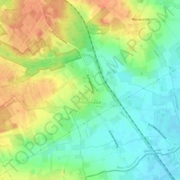
Name: Hollebeke topographic map, elevation, terrain.
Location: Hollebeke, Ieper, West-Vlaanderen, België (50.79361 2.91766 50.82155 2.96343)
Average elevation: 125 ft
Minimum elevation: 62 ft
Maximum elevation: 197 ft
Make a donation
Gear up for your next adventure:
As an Amazon Associate, this site earns from qualifying purchases at no extra cost to you.
Other topographic maps
Click on a map to view its topography, its elevation and its terrain.
Make a donation
Gear up for your next adventure:
As an Amazon Associate, this site earns from qualifying purchases at no extra cost to you.