
Khumjung topographic map
Interactive map
Click on the map to display elevation.
About this map
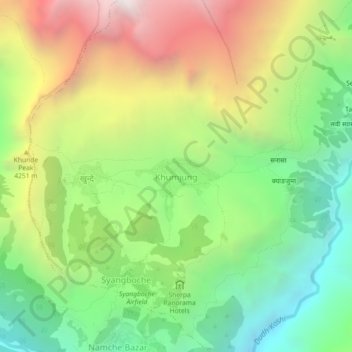
Name: Khumjung topographic map, elevation, terrain.
Average elevation: 12,756 ft
Minimum elevation: 9,665 ft
Maximum elevation: 17,162 ft
Khumjung (Nepali: खुम्जुंग) is a village in Khumbu Pasanglhamu rural municipality of Solukhumbu District in Province No. 1 of north-eastern Nepal. It is located in the Khumbu subregion inside Sagarmatha National Park, a world heritage site. The village is at an elevation of 3,790 metres above sea level, and is situated near Mount Khumbila.
Other topographic maps
Click on a map to view its topography, its elevation and its terrain.
Mount Everest
Nepal > Koshi Province > Solukhumbu
Mount Everest, Khumbupasanglahmu, Solukhumbu, Koshi Province, Nepal
Average elevation: 25,755 ft
Himalayas
Nepal > Koshi Province > Solukhumbu
Himalayas, Khumbupasanglahmu, Solukhumbu, Koshi Province, Nepal
Average elevation: 24,787 ft
Mount Everest
Nepal > Koshi Province > Solukhumbu
Mount Everest, Khumbupasanglahmu, Solukhumbu, Koshi Province, Nepal
Average elevation: 25,745 ft
Phortse
Nepal > Koshi Province > Solukhumbu
Phortse, Khumbupasanglahmu, Solukhumbu, Koshi Province, 56002, Nepal
Average elevation: 13,025 ft
Lukla
Nepal > Koshi Province > Solukhumbu
Lukla, Khumbupasanglahmu, Solukhumbu, Koshi Province, Nepal
Average elevation: 9,829 ft