
Make a donation
Gear up for your next adventure:
As an Amazon Associate, this site earns from qualifying purchases at no extra cost to you.
Brescia topographic map
Click on the map to display elevation.
Make a donation
Gear up for your next adventure:
As an Amazon Associate, this site earns from qualifying purchases at no extra cost to you.
Brescia
Due to the altitude and morphological variety and the presence of large lakes, the province includes all kinds of biomes in Europe: from something similar to the maquis shrubland up to the perennial snow of Adamello (with the largest glacier in the Italian Alps).
Make a donation
Gear up for your next adventure:
As an Amazon Associate, this site earns from qualifying purchases at no extra cost to you.
About this map
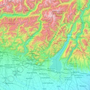
Name: Brescia topographic map, elevation, terrain.
Location: Brescia, Lombardy, Italy (45.20425 9.83629 46.35485 10.84268)
Average elevation: 2,799 ft
Minimum elevation: 49 ft
Maximum elevation: 11,762 ft
Make a donation
Gear up for your next adventure:
As an Amazon Associate, this site earns from qualifying purchases at no extra cost to you.
Other topographic maps
Click on a map to view its topography, its elevation and its terrain.