
Kawkawa Lake topographic map
Click on the map to display elevation.
About this map
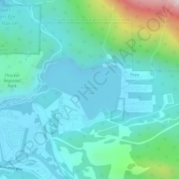
Name: Kawkawa Lake topographic map, elevation, terrain.
Location: Kawkawa Lake, Hope, British Columbia, Canada (49.38208 -121.41120 49.39115 -121.39287)
Average elevation: 653 ft
Minimum elevation: 157 ft
Maximum elevation: 2,956 ft
Other topographic maps
Click on a map to view its topography, its elevation and its terrain.
Fraser River
Canada > British Columbia > Chilliwack > Hope > Deroche
Similar to the Columbia River Gorge east of Portland, Oregon, the Fraser exploits a topographic cleft between two mountain ranges separating a more continental climate (in this case, that of the British Columbia Interior) from a milder climate near the coast. When an Arctic high-pressure area moves into the…
Average elevation: 2,838 ft