
Imst topographic map
Interactive map
Click on the map to display elevation.
About this map
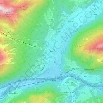
Name: Imst topographic map, elevation, terrain.
Location: Imst, Bezirk Imst, 6460, Österreich (47.19815 10.70070 47.27815 10.78070)
Average elevation: 3,773 ft
Minimum elevation: 2,306 ft
Maximum elevation: 8,527 ft
Other topographic maps
Click on a map to view its topography, its elevation and its terrain.
Vent
Österreich > Bezirk Imst > Sölden
Vent, Sölden, Bezirk Imst, 6458, Österreich
Average elevation: 7,779 ft
Unterlängenfeld
Österreich > Bezirk Imst > Längenfeld
Unterlängenfeld, Längenfeld, Bezirk Imst, 6444, Österreich
Average elevation: 5,262 ft
Hochimst
Österreich > Bezirk Imst > Imst
Hochimst, Imst, Bezirk Imst, 6460, Österreich
Average elevation: 3,520 ft