
Make a donation
Gear up for your next adventure:
As an Amazon Associate, this site earns from qualifying purchases at no extra cost to you.
Yalata topographic map
Click on the map to display elevation.
Make a donation
Gear up for your next adventure:
As an Amazon Associate, this site earns from qualifying purchases at no extra cost to you.
About this map
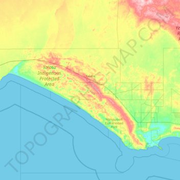
Name: Yalata topographic map, elevation, terrain.
Average elevation: 144 ft
Minimum elevation: -3 ft
Maximum elevation: 699 ft
Make a donation
Gear up for your next adventure:
As an Amazon Associate, this site earns from qualifying purchases at no extra cost to you.
Other topographic maps
Click on a map to view its topography, its elevation and its terrain.
Mount Sunderland
Australia > South Australia > Pastoral Unincorporated Area
Average elevation: 2,238 ft
Make a donation
Gear up for your next adventure:
As an Amazon Associate, this site earns from qualifying purchases at no extra cost to you.
Moomba Gas and Oil Field
Australia > South Australia > Pastoral Unincorporated Area > Moomba Gas and Oil Field
Average elevation: 118 ft