
St Albans topographic map
Interactive map
Click on the map to display elevation.
About this map
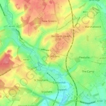
Name: St Albans topographic map, elevation, terrain.
Location: St Albans, Hertfordshire, England, United Kingdom (51.72913 -0.37529 51.78007 -0.29102)
Average elevation: 338 ft
Minimum elevation: 226 ft
Maximum elevation: 463 ft
The borough consisted of the ancient parish of St Albans (also known as the Abbey parish) and parts of the parishes of St Michael and St Peter. The borough was reformed by the Municipal Corporations Act 1835 to become a municipal borough, and the boundary was adjusted to additionally include part of the parish of St Stephen. On 28 August 1877 the borough gained city status, following the elevation of St Albans Abbey to become a cathedral. The boundary was also adjusted in 1877 to include part of the parish of Sandridge.
Other topographic maps
Click on a map to view its topography, its elevation and its terrain.
Hertsmere
United Kingdom > England > Hertfordshire
Hertsmere, Hertfordshire, England, United Kingdom
Average elevation: 312 ft
Old Town
United Kingdom > England > Hertfordshire > Dacorum
Old Town, Dacorum, Hertfordshire, England, HP1 3AF, United Kingdom
Average elevation: 407 ft
Stevenage
United Kingdom > England > Hertfordshire
Stevenage, Hertfordshire, England, United Kingdom
Average elevation: 354 ft
Pelham Gate
United Kingdom > England > Hertfordshire > East Hertfordshire
Pelham Gate, Brent Pelham, East Hertfordshire, Hertfordshire, England, SG9 0HL, United Kingdom
Average elevation: 371 ft
St Paul's Walden
United Kingdom > England > Hertfordshire > North Hertfordshire
St Paul's Walden, North Hertfordshire, Hertfordshire, England, United Kingdom
Average elevation: 397 ft
Home Wood
United Kingdom > England > Hertfordshire > St Albans > Sandridge
Home Wood, Marshalswick, Sandridge, St Albans, Hertfordshire, England, AL4 0XR, United Kingdom
Average elevation: 295 ft
St Albans
United Kingdom > England > Hertfordshire
St Albans, Hertfordshire, England, United Kingdom
Average elevation: 351 ft
Much Hadham
United Kingdom > England > Hertfordshire > East Hertfordshire
Much Hadham, East Hertfordshire, Hertfordshire, England, United Kingdom
Average elevation: 262 ft
Harpenden
United Kingdom > England > Hertfordshire > St Albans > Hatching Green
Harpenden, Hatching Green, St Albans, Hertfordshire, England, United Kingdom
Average elevation: 390 ft
Kinsbourne Green
United Kingdom > England > Hertfordshire > St Albans
Kinsbourne Green, Harpenden Rural, St Albans, Hertfordshire, England, AL5 3PJ, United Kingdom
Average elevation: 440 ft
Letchworth
United Kingdom > England > Hertfordshire
Letchworth, Hertfordshire, England, United Kingdom
Average elevation: 266 ft
Hemel Hempstead
United Kingdom > England > Hertfordshire > Dacorum
Hemel Hempstead, Dacorum, Hertfordshire, England, HP1 1EW, United Kingdom
Average elevation: 427 ft
Bishops Stortford Elsan Point
United Kingdom > England > Hertfordshire > East Hertfordshire
Bishops Stortford Elsan Point, East Hertfordshire, Hertfordshire, East of England, England, CM23 3BL, United Kingdom
Average elevation: 256 ft
Buntingford
United Kingdom > England > Hertfordshire > East Hertfordshire
Buntingford, East Hertfordshire, Hertfordshire, England, United Kingdom
Average elevation: 361 ft
Hitchin
United Kingdom > England > Hertfordshire > North Hertfordshire
Hitchin, North Hertfordshire, Hertfordshire, England, SG5 1BB, United Kingdom
Average elevation: 299 ft
Elstree
United Kingdom > England > Hertfordshire > Hertsmere > Elstree
Elstree, Hertsmere, Hertfordshire, East of England, England, WD6 3FE, United Kingdom
Average elevation: 344 ft
Thorley
United Kingdom > England > Hertfordshire > East Hertfordshire > Thorley
Thorley, East Hertfordshire, Hertfordshire, East of England, England, United Kingdom
Average elevation: 269 ft
Rounton
United Kingdom > England > Hertfordshire > Watford > Rounton
Rounton, Watford, Hertfordshire, East of England, England, WD17 4DU, United Kingdom
Average elevation: 256 ft
Bushey Heath
United Kingdom > England > Hertfordshire > Hertsmere > Bushey Heath
Bushey Heath, Hertsmere, Hertfordshire, East of England, England, WD23 1SH, United Kingdom
Average elevation: 361 ft
Hatfield
United Kingdom > England > Hertfordshire > Welwyn Hatfield
Hatfield, Welwyn Hatfield, Hertfordshire, England, United Kingdom
Average elevation: 295 ft
Barley
United Kingdom > England > Hertfordshire > North Hertfordshire
Barley, North Hertfordshire, Hertfordshire, England, United Kingdom
Average elevation: 338 ft
Watford
United Kingdom > England > Hertfordshire
Watford, Hertfordshire, England, United Kingdom
Average elevation: 253 ft
Welwyn
United Kingdom > England > Hertfordshire > Welwyn Hatfield > Oaklands
Welwyn, Oaklands, Welwyn Hatfield, Hertfordshire, England, United Kingdom
Average elevation: 335 ft
Welwyn Garden City
United Kingdom > England > Hertfordshire > Welwyn Hatfield
Welwyn Garden City, Welwyn Hatfield, Hertfordshire, England, AL8 6TP, United Kingdom
Average elevation: 292 ft
Berkhamsted
United Kingdom > England > Hertfordshire > Dacorum > Berkhamsted
Berkhamsted, Dacorum, Hertfordshire, England, United Kingdom
Average elevation: 466 ft
North Hertfordshire
United Kingdom > England > Hertfordshire
North Hertfordshire, Hertfordshire, England, United Kingdom
Average elevation: 299 ft
Bricket Wood
United Kingdom > England > Hertfordshire > St Albans
Bricket Wood, St Albans, Hertfordshire, England, AL2 3QS, United Kingdom
Average elevation: 269 ft
Therfield
United Kingdom > England > Hertfordshire > North Hertfordshire
Therfield, North Hertfordshire, Hertfordshire, England, United Kingdom
Average elevation: 400 ft