
Warner Robins topographic map
Click on the map to display elevation.
About this map
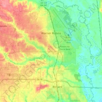
Name: Warner Robins topographic map, elevation, terrain.
Location: Warner Robins, Houston County, Georgia, United States (32.52272 -83.74775 32.66639 -83.57587)
Average elevation: 331 ft
Minimum elevation: 210 ft
Maximum elevation: 502 ft
Houston County trails, hiking, mountain biking, running and outdoor activities
Other topographic maps
Click on a map to view its topography, its elevation and its terrain.
Honey Ridge Plantation
United States > Georgia > Houston County > Warner Robins
Average elevation: 377 ft