
Make a donation
Gear up for your next adventure:
As an Amazon Associate, this site earns from qualifying purchases at no extra cost to you.
Tlayacapan topographic map
Click on the map to display elevation.
Make a donation
Gear up for your next adventure:
As an Amazon Associate, this site earns from qualifying purchases at no extra cost to you.
Tlayacapan
The capillas de calpulli cover other types of sites in the four pre-Hispanic neighborhoods. They include San Jerónimo, Santa Marta, Santa Cruz de Altica, San Diego, La Magdalena, San Lorenzo, La Tlazcalchica, San Nicolás, La Concepcón, San Miguel, La Asunción, San Martín, La Natividad and Los Reyes. Those chapels on the outskirts, such as San Nicolás, San Pedro, San Lucas, Las Animas and El Transito, mark traditional exits from the pre-Hispanic village. The smallest chapels, also called ermitas (hermitages) mark topographic sites or other devotional areas. The festival of the Chapel of Santa Cruz of Altica is on 3 May, as well as the chapel of Tlazcalchica. The Capilla de la Natividad contains the Museo del Alfarero or Potters’ Museum.
Make a donation
Gear up for your next adventure:
As an Amazon Associate, this site earns from qualifying purchases at no extra cost to you.
About this map
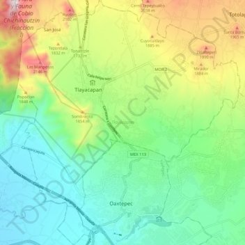
Name: Tlayacapan topographic map, elevation, terrain.
Location: Tlayacapan, Morelos, Mexico (18.89366 -99.01618 18.99291 -98.92109)
Average elevation: 5,223 ft
Minimum elevation: 4,078 ft
Maximum elevation: 7,657 ft
Make a donation
Gear up for your next adventure:
As an Amazon Associate, this site earns from qualifying purchases at no extra cost to you.
Other topographic maps
Click on a map to view its topography, its elevation and its terrain.
Cuernavaca
Mexico > Morelos > Cuernavaca
The city is located in a tropical region, but its temperature is fairly constant at 21–26 °C (70–79 °F). It is located on the southern slope of the Sierra de Chichinautzin mountains. In the morning, warm air flows up the mountains from the valley below and in the late afternoon, cooler air flows down…
Average elevation: 5,978 ft
Make a donation
Gear up for your next adventure:
As an Amazon Associate, this site earns from qualifying purchases at no extra cost to you.
Make a donation
Gear up for your next adventure:
As an Amazon Associate, this site earns from qualifying purchases at no extra cost to you.