
Make a donation
Gear up for your next adventure:
As an Amazon Associate, this site earns from qualifying purchases at no extra cost to you.
Büren topographic map
Click on the map to display elevation.
Make a donation
Gear up for your next adventure:
As an Amazon Associate, this site earns from qualifying purchases at no extra cost to you.
Büren
Büren liegt im äußersten Südwesten der Region Ostwestfalen-Lippe nördlich des Sauerlands, am Südwestrand der Paderborner Hochfläche und westlich des Sintfelds im Herzen des Bürener Landes. In der Stadt mündet die Afte in die Alme. Das Stadtgebiet umfasst Höhenlagen von 190 bis 360 Meter über Normalnull.
Make a donation
Gear up for your next adventure:
As an Amazon Associate, this site earns from qualifying purchases at no extra cost to you.
About this map
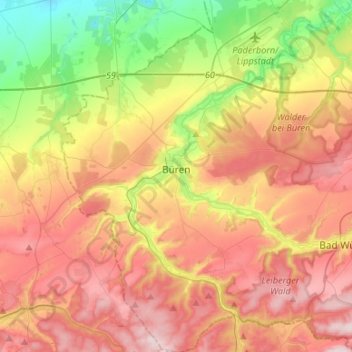
Name: Büren topographic map, elevation, terrain.
Location: Büren, Kreis Paderborn, Nordrhein-Westfalen, 33142, Deutschland (51.46621 8.47266 51.63171 8.71375)
Average elevation: 932 ft
Minimum elevation: 348 ft
Maximum elevation: 1,496 ft
Make a donation
Gear up for your next adventure:
As an Amazon Associate, this site earns from qualifying purchases at no extra cost to you.
Other topographic maps
Click on a map to view its topography, its elevation and its terrain.
Barkhausen
Deutschland > Nordrhein-Westfalen > Kreis Paderborn > Paderborn > Wewer
Average elevation: 456 ft
Aabachtalsperre
Deutschland > Nordrhein-Westfalen > Kreis Paderborn > Bad Wünnenberg
Die Aabachtalsperre liegt im Kreis Paderborn am Rand der Briloner Höhen zwischen Bad Wünnenberg im Nordwesten und Marsberg im Südosten. Das 27,2 km² große Einzugsgebiet der Talsperre erstreckt sich im Wesentlichen nach Südosten durch das Sintfeld und wird flankiert durch den „Fürstenberger Wald“ im…
Average elevation: 1,250 ft
Make a donation
Gear up for your next adventure:
As an Amazon Associate, this site earns from qualifying purchases at no extra cost to you.
Ringelstein
Deutschland > Nordrhein-Westfalen > Kreis Paderborn > Büren > Harth
Average elevation: 1,096 ft
Oberntudorf
Deutschland > Nordrhein-Westfalen > Kreis Paderborn > Salzkotten
Average elevation: 561 ft
Bad Lippspringe
Deutschland > Nordrhein-Westfalen > Kreis Paderborn > Bad Lippspringe > Bad Lippspringe
Average elevation: 531 ft
Make a donation
Gear up for your next adventure:
As an Amazon Associate, this site earns from qualifying purchases at no extra cost to you.
Wewelsburg
Deutschland > Nordrhein-Westfalen > Kreis Paderborn > Büren
Das Dorf Wewelsburg liegt am Westrand der Paderborner Hochfläche, auf der Brenkener Bergplatte, oberhalb des tief eingeschnittenen Almetales, das die Grenze zum Hellwegraum darstellt. Die Gemarkung Wewelsburg umfasst Höhenbereiche von 163 m ü. NN im Almetal bis 340 m ü. NN an der L 754.
Average elevation: 728 ft
Make a donation
Gear up for your next adventure:
As an Amazon Associate, this site earns from qualifying purchases at no extra cost to you.
Siedlung Forst
Deutschland > Nordrhein-Westfalen > Kreis Paderborn > Schwaney
Average elevation: 1,060 ft
Am Zollpfosten
Deutschland > Nordrhein-Westfalen > Kreis Paderborn > Büren
Average elevation: 1,214 ft
Make a donation
Gear up for your next adventure:
As an Amazon Associate, this site earns from qualifying purchases at no extra cost to you.
Make a donation
Gear up for your next adventure:
As an Amazon Associate, this site earns from qualifying purchases at no extra cost to you.
Mantinghausen
Deutschland > Nordrhein-Westfalen > Kreis Paderborn > Salzkotten
Average elevation: 276 ft
Make a donation
Gear up for your next adventure:
As an Amazon Associate, this site earns from qualifying purchases at no extra cost to you.
Tallesee Mittelsee
Deutschland > Nordrhein-Westfalen > Kreis Paderborn > Paderborn
Average elevation: 387 ft
Nesthauser See
Deutschland > Nordrhein-Westfalen > Kreis Paderborn > Paderborn > Sande
Average elevation: 331 ft
Herbram
Deutschland > Nordrhein-Westfalen > Kreis Paderborn > Lichtenau > Herbram
Average elevation: 1,040 ft
Make a donation
Gear up for your next adventure:
As an Amazon Associate, this site earns from qualifying purchases at no extra cost to you.
Borchen
Deutschland > Nordrhein-Westfalen > Kreis Paderborn > Borchen > Borchen
Average elevation: 597 ft
Habichtsee
Deutschland > Nordrhein-Westfalen > Kreis Paderborn > Paderborn > Sennelager
Average elevation: 367 ft
Make a donation
Gear up for your next adventure:
As an Amazon Associate, this site earns from qualifying purchases at no extra cost to you.
Asseln
Deutschland > Nordrhein-Westfalen > Kreis Paderborn > Lichtenau > Asseln
Average elevation: 1,099 ft
Schloß Hamborn
Deutschland > Nordrhein-Westfalen > Kreis Paderborn > Borchen > Schloss Hamborn
Average elevation: 702 ft
Make a donation
Gear up for your next adventure:
As an Amazon Associate, this site earns from qualifying purchases at no extra cost to you.
Herbram-Wald
Deutschland > Nordrhein-Westfalen > Kreis Paderborn
Herbram-Wald gehört wie Ostwestfalen-Lippe insgesamt zum ozeanischen Klimabereich Nordwestdeutschlands, dem es geringe Temperaturgegensätze und milde Winter verdankt. Allerdings sind schon kontinentale Einflüsse wirksam. So liegt die Temperatur im Sommer höher und die Nächte sind kühler als in größerer…
Average elevation: 1,093 ft
Holsen
Deutschland > Nordrhein-Westfalen > Kreis Paderborn > Salzkotten > Holsen
Average elevation: 285 ft