
Make a donation
Gear up for your next adventure:
As an Amazon Associate, this site earns from qualifying purchases at no extra cost to you.
Gaza Strip topographic map
Click on the map to display elevation.
Make a donation
Gear up for your next adventure:
As an Amazon Associate, this site earns from qualifying purchases at no extra cost to you.
Gaza Strip
The topography of the Gaza Strip is dominated by three ridges parallel to the coastline, which consist of Pleistocene-Holocene aged calcareous aeolian (wind deposited) sandstones, locally referred to as "kurkar", intercalated with red-coloured fine grained paleosols, referred to as "hamra". The three ridges are separated by wadis, which are filled with alluvial deposits. The terrain is flat or rolling, with dunes near the coast. The highest point is Abu 'Awdah (Joz Abu 'Auda), at 105 m (344 ft) above sea level.
Make a donation
Gear up for your next adventure:
As an Amazon Associate, this site earns from qualifying purchases at no extra cost to you.
About this map
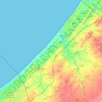
Name: Gaza Strip topographic map, elevation, terrain.
Location: Gaza Strip, Palestinian Territory (31.22013 34.21590 31.59685 34.56732)
Average elevation: 144 ft
Minimum elevation: 0 ft
Maximum elevation: 558 ft
Make a donation
Gear up for your next adventure:
As an Amazon Associate, this site earns from qualifying purchases at no extra cost to you.
Other topographic maps
Click on a map to view its topography, its elevation and its terrain.
Sanur
Palestinian Territory > Area A
Sanur is located in the highlands of the northern West Bank. The village is situated on an isolated hilltop along the western edge of the valley and seasonal lake of Marj Sanur, which is named after the village. To the west, Sanur is connected to the Hawarah Ridge of the Zawiya Highlands through a low-lying…
Average elevation: 1,388 ft
Make a donation
Gear up for your next adventure:
As an Amazon Associate, this site earns from qualifying purchases at no extra cost to you.
Make a donation
Gear up for your next adventure:
As an Amazon Associate, this site earns from qualifying purchases at no extra cost to you.
Make a donation
Gear up for your next adventure:
As an Amazon Associate, this site earns from qualifying purchases at no extra cost to you.
Nabi Daniel
Palestinian Territory > Judea and Samaria > Area C > Beitar Ilit > Sde Boaz
Average elevation: 2,904 ft
Make a donation
Gear up for your next adventure:
As an Amazon Associate, this site earns from qualifying purchases at no extra cost to you.
Make a donation
Gear up for your next adventure:
As an Amazon Associate, this site earns from qualifying purchases at no extra cost to you.
Ma'ale Hever;Maale Hever
Palestinian Territory > Judea and Samaria > Area C
Average elevation: 2,500 ft
Talmon
Palestinian Territory > Judea and Samaria > Area C
Located at an elevation of nearly 600 metres and 18 km east of Modiin, it is organised as a community settlement and falls under the jurisdiction of Mateh Binyamin Regional Council. In 2022, it had a population of 5,379.
Average elevation: 1,713 ft
Make a donation
Gear up for your next adventure:
As an Amazon Associate, this site earns from qualifying purchases at no extra cost to you.
Khallet Afana
Palestinian Territory > Judea and Samaria > Area C > Beitar Ilit
Average elevation: 2,982 ft
Nablus
Palestinian Territory > Area A
Insofar as the hilly topography of the site would allow, the city was built on a Roman grid plan and settled with veterans who fought in the victorious legions and other foreign colonists. In the 2nd century CE, Emperor Hadrian built a grand theater in Neapolis that could seat up to 7,000 people. Coins found…
Average elevation: 2,116 ft
Make a donation
Gear up for your next adventure:
As an Amazon Associate, this site earns from qualifying purchases at no extra cost to you.
Make a donation
Gear up for your next adventure:
As an Amazon Associate, this site earns from qualifying purchases at no extra cost to you.
Make a donation
Gear up for your next adventure:
As an Amazon Associate, this site earns from qualifying purchases at no extra cost to you.
Make a donation
Gear up for your next adventure:
As an Amazon Associate, this site earns from qualifying purchases at no extra cost to you.
Homesh
Palestinian Territory > Judea and Samaria > Area C > Shomron Regional Council
Average elevation: 1,483 ft
Mevo Dotan
Palestinian Territory > Judea and Samaria > Area C > Shomron Regional Council
Average elevation: 866 ft
Make a donation
Gear up for your next adventure:
As an Amazon Associate, this site earns from qualifying purchases at no extra cost to you.
Make a donation
Gear up for your next adventure:
As an Amazon Associate, this site earns from qualifying purchases at no extra cost to you.
Make a donation
Gear up for your next adventure:
As an Amazon Associate, this site earns from qualifying purchases at no extra cost to you.
Make a donation
Gear up for your next adventure:
As an Amazon Associate, this site earns from qualifying purchases at no extra cost to you.
Make a donation
Gear up for your next adventure:
As an Amazon Associate, this site earns from qualifying purchases at no extra cost to you.
Make a donation
Gear up for your next adventure:
As an Amazon Associate, this site earns from qualifying purchases at no extra cost to you.
Rotem
Palestinian Territory > Judea and Samaria > Area C > Arvot Hayarden Regional Council
Average elevation: -394 ft
Make a donation
Gear up for your next adventure:
As an Amazon Associate, this site earns from qualifying purchases at no extra cost to you.
Make a donation
Gear up for your next adventure:
As an Amazon Associate, this site earns from qualifying purchases at no extra cost to you.
Qalandiya Refugee Camp
Palestinian Territory > Area C > Qalandiya Refugee Camp
Average elevation: 2,418 ft
Make a donation
Gear up for your next adventure:
As an Amazon Associate, this site earns from qualifying purchases at no extra cost to you.
Meithalun
Palestinian Territory > Area A > Meithalun
The town is situated along the western edge of Marj Sanur, a valley and seasonal lake. It is the largest locality, of seven total, bordering Marj Sanur and controls the largest share of its fertile lands. It has an average elevation of 385 meters above sea level and is not elevated from its immediate…
Average elevation: 1,322 ft
Make a donation
Gear up for your next adventure:
As an Amazon Associate, this site earns from qualifying purchases at no extra cost to you.
Make a donation
Gear up for your next adventure:
As an Amazon Associate, this site earns from qualifying purchases at no extra cost to you.
Beit Fajjar
Palestinian Territory > Area B
The site's high altitude was the highest point in the area and later the town expanded into other hills. During British rule in Palestine in the 1920s-1940s, Beit Fajjar was used as an observation point for the Bethlehem-Hebron area.
Average elevation: 2,881 ft
Make a donation
Gear up for your next adventure:
As an Amazon Associate, this site earns from qualifying purchases at no extra cost to you.