
Make a donation
Gear up for your next adventure:
As an Amazon Associate, this site earns from qualifying purchases at no extra cost to you.
Wiedenest topographic map
Click on the map to display elevation.
Make a donation
Gear up for your next adventure:
As an Amazon Associate, this site earns from qualifying purchases at no extra cost to you.
About this map
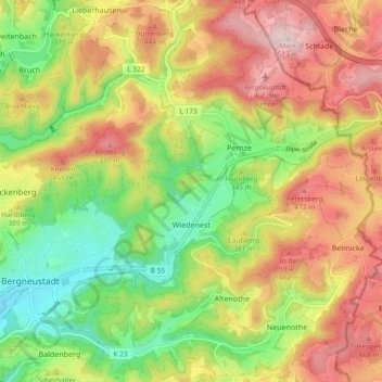
Name: Wiedenest topographic map, elevation, terrain.
Average elevation: 1,184 ft
Minimum elevation: 702 ft
Maximum elevation: 1,703 ft
Make a donation
Gear up for your next adventure:
As an Amazon Associate, this site earns from qualifying purchases at no extra cost to you.
Other topographic maps
Click on a map to view its topography, its elevation and its terrain.
Belmicke
Deutschland > Nordrhein-Westfalen > Oberbergischer Kreis > Bergneustadt
Belmicke liegt in Luftlinie ca. 5,4 km östlich von Bergneustadt auf der Wasserscheide zwischen den Flusssystemen Lenne/Ruhr und Agger/Sieg. Aufgrund seiner Höhenlage, die Kirche steht auf ca. 435 m ü. NN und die Höhenzüge um den Ort erreichen teilweise 480 m ü. NN, bestehen sehr gute…
Average elevation: 1,306 ft
Immicke
Deutschland > Nordrhein-Westfalen > Oberbergischer Kreis > Bergneustadt > Baldenberg
Average elevation: 1,010 ft
Altenothe
Deutschland > Nordrhein-Westfalen > Oberbergischer Kreis > Bergneustadt
Average elevation: 1,168 ft
Pernze
Deutschland > Nordrhein-Westfalen > Oberbergischer Kreis > Bergneustadt
Average elevation: 1,247 ft
Make a donation
Gear up for your next adventure:
As an Amazon Associate, this site earns from qualifying purchases at no extra cost to you.
Baldenberg
Deutschland > Nordrhein-Westfalen > Oberbergischer Kreis > Bergneustadt
Average elevation: 948 ft
Wiedenest
Deutschland > Nordrhein-Westfalen > Oberbergischer Kreis > Bergneustadt
Average elevation: 1,099 ft