
Make a donation
Gear up for your next adventure:
As an Amazon Associate, this site earns from qualifying purchases at no extra cost to you.
Belmicke topographic map
Click on the map to display elevation.
Make a donation
Gear up for your next adventure:
As an Amazon Associate, this site earns from qualifying purchases at no extra cost to you.
Belmicke
Belmicke liegt in Luftlinie ca. 5,4 km östlich von Bergneustadt auf der Wasserscheide zwischen den Flusssystemen Lenne/Ruhr und Agger/Sieg. Aufgrund seiner Höhenlage, die Kirche steht auf ca. 435 m ü. NN und die Höhenzüge um den Ort erreichen teilweise 480 m ü. NN, bestehen sehr gute Aussichtsmöglichkeiten über das obere Othe- oder das Dörspetal. Bei klarer Sicht reicht der Blick bis zum Siebengebirge und zur Eifel. Belmicke liegt 10 Minuten von Bergneustadt und der A 4 entfernt und bis nach Drolshagen bzw. auch der Autobahnauffahrt zur A 45 sind es ca. 5 Minuten.
Make a donation
Gear up for your next adventure:
As an Amazon Associate, this site earns from qualifying purchases at no extra cost to you.
About this map
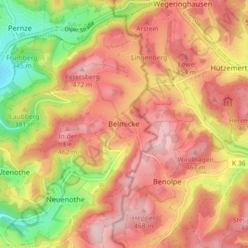
Name: Belmicke topographic map, elevation, terrain.
Average elevation: 1,306 ft
Minimum elevation: 883 ft
Maximum elevation: 1,578 ft
Make a donation
Gear up for your next adventure:
As an Amazon Associate, this site earns from qualifying purchases at no extra cost to you.
Other topographic maps
Click on a map to view its topography, its elevation and its terrain.
Wiedenest
Deutschland > Nordrhein-Westfalen > Oberbergischer Kreis > Bergneustadt
Average elevation: 1,260 ft
Wiedenest
Deutschland > Nordrhein-Westfalen > Oberbergischer Kreis > Bergneustadt
Average elevation: 1,184 ft