
Make a donation
Gear up for your next adventure:
As an Amazon Associate, this site earns from qualifying purchases at no extra cost to you.
Eksel topographic map
Click on the map to display elevation.
Make a donation
Gear up for your next adventure:
As an Amazon Associate, this site earns from qualifying purchases at no extra cost to you.
Eksel
Eksel ligt aan de noordrand van het Kempens Plateau, op een hoogte van 41 tot 64 meter. Het ligt op de waterscheiding tussen het stroomgebied van de Schelde (de Grote Nete ontspringt hier) en het stroomgebied van de Maas: De Bolissenbeek, zijrivier van de Dommel, vormt de oostgrens van Eksel. De Winnerloop, die ten noorden van Winner ontspringt, loopt in noordelijke richting en komt nabij Neerpelt in de Dommel uit.
Make a donation
Gear up for your next adventure:
As an Amazon Associate, this site earns from qualifying purchases at no extra cost to you.
About this map
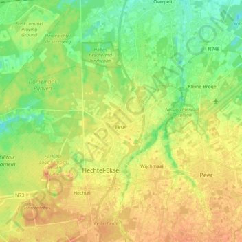
Name: Eksel topographic map, elevation, terrain.
Location: Eksel, Hechtel-Eksel, Maaseik, Limburg, Vlaanderen, België (51.13150 5.26094 51.18188 5.43758)
Average elevation: 187 ft
Minimum elevation: 128 ft
Maximum elevation: 240 ft
Make a donation
Gear up for your next adventure:
As an Amazon Associate, this site earns from qualifying purchases at no extra cost to you.
Other topographic maps
Click on a map to view its topography, its elevation and its terrain.