
Make a donation
Gear up for your next adventure:
As an Amazon Associate, this site earns from qualifying purchases at no extra cost to you.
Castle Provincial Park topographic map
Click on the map to display elevation.
Make a donation
Gear up for your next adventure:
As an Amazon Associate, this site earns from qualifying purchases at no extra cost to you.
Castle Provincial Park
The Castle Provincial Park has a unique climate which has allowed the growth of many unique plant and animal species. This climate is formed because of the transition of subalpine forest to tundra, and is characterized by short summers interchanged with long, snowy winters. Precipitation varies throughout the park due to the interplay of the Pacific Maritime and Arctic Continental air masses. Factors of climate concern in the Castle Provincial Park include wind exposure, moisture patterns such as snow accumulation and availability, volcanic debris, topography, and seasonal temperature changes.
Make a donation
Gear up for your next adventure:
As an Amazon Associate, this site earns from qualifying purchases at no extra cost to you.
About this map
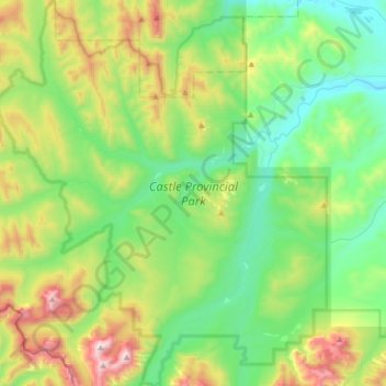
Name: Castle Provincial Park topographic map, elevation, terrain.
Average elevation: 5,207 ft
Minimum elevation: 4,006 ft
Maximum elevation: 8,150 ft
Make a donation
Gear up for your next adventure:
As an Amazon Associate, this site earns from qualifying purchases at no extra cost to you.
Other topographic maps
Click on a map to view its topography, its elevation and its terrain.
Beaver Mines Lake
Canada > Alberta > Municipal District of Pincher Creek No. 9
Average elevation: 5,046 ft
Make a donation
Gear up for your next adventure:
As an Amazon Associate, this site earns from qualifying purchases at no extra cost to you.