
Make a donation
Gear up for your next adventure:
As an Amazon Associate, this site earns from qualifying purchases at no extra cost to you.
Rwenzori Mountains topographic map
Click on the map to display elevation.
Make a donation
Gear up for your next adventure:
As an Amazon Associate, this site earns from qualifying purchases at no extra cost to you.
Rwenzori Mountains
There is no water shortage in the Ruwenzori; yet, several members of the afro-alpine family resemble species that normally thrive in desert climates. The reason lies in their similar water economy. Water is not always readily available to the afroalpine plants when they need it. In addition, nightly frosts affect the sap transport in the plants and the intake of water by its roots. As the day begins, the air temperature and radiation level rise rapidly, putting strenuous demands on the exposed parts of the plants as they try to meet the transpiration demands of the leaves and maintain a proper water balance. To counter the effects of freezing, the afro-alpine plants have developed the insulation systems that give them such a striking appearance. These adaptations become more prominent as the elevation increases.
Make a donation
Gear up for your next adventure:
As an Amazon Associate, this site earns from qualifying purchases at no extra cost to you.
About this map
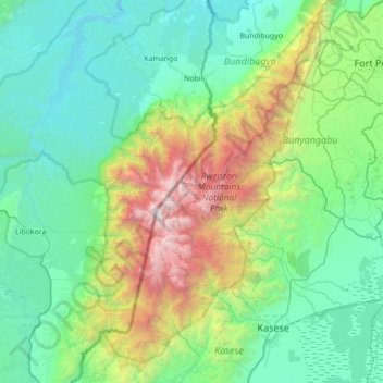
Name: Rwenzori Mountains topographic map, elevation, terrain.
Location: Rwenzori Mountains, Kasese, Western Region, Uganda (0.07049 29.74264 0.77055 30.18341)
Average elevation: 5,151 ft
Minimum elevation: 2,244 ft
Maximum elevation: 16,460 ft
Make a donation
Gear up for your next adventure:
As an Amazon Associate, this site earns from qualifying purchases at no extra cost to you.
Other topographic maps
Click on a map to view its topography, its elevation and its terrain.