
Kilembe Quarters topographic map
Interactive map
Click on the map to display elevation.
About this map
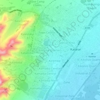
Name: Kilembe Quarters topographic map, elevation, terrain.
Location: Kilembe Quarters, Kasese, Western Region, Uganda (0.15216 30.05550 0.19216 30.09550)
Average elevation: 3,340 ft
Minimum elevation: 3,097 ft
Maximum elevation: 4,180 ft
Other topographic maps
Click on a map to view its topography, its elevation and its terrain.
Rwenzori Mountains
Rwenzori Mountains, Kasese, Western Region, Uganda
Average elevation: 5,151 ft
Middle Portal
Middle Portal, Kasese, Western Region, Uganda
Average elevation: 12,946 ft
Coronation Glacier
Coronation Glacier, South Ridge Route, Kasese, Western Region, Uganda
Average elevation: 14,452 ft
Mount Luigi di Savoia
Mount Luigi di Savoia, South Ridge Route, Kasese, Western Region, Uganda
Average elevation: 13,497 ft