Geolocate

Loudon topographic map

Interactive map

Click on the map to display elevation.

About this map

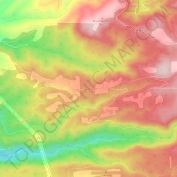
Name: Loudon topographic map, elevation, terrain.

Location: Loudon, Multnomah County, Oregon, 97019, United States (45.48477 -122.25974 45.52477 -122.21974)

Average elevation: 909 ft

Minimum elevation: 253 ft

Maximum elevation: 1,348 ft

Routes: Multnomah County GPS tracks, routes, trails, hikes

Other topographic maps

Click on a map to view its topography, its elevation and its terrain.

Gresham

United States > Oregon > Multnomah County

Though much of Gresham is relatively flat, it is characterized by a hill on its eastern border. Northeast Gresham is also hilly, particularly where the city meets Troutdale toward the Columbia River. Its elevation is 325 feet (99 m). Johnson Creek, which begins at the foothills of the Cascade Mountains, runs…

Average elevation: 295 ft

Portland

United States > Oregon > Multnomah County

Portland features a striking and varied topography characterized by its location at the confluence of the Willamette and Columbia Rivers. The city lies within the fertile Willamette Valley, flanked by the snow-capped Cascade Mountains to the east, including the prominent Mount Hood, and the less elevated…

Average elevation: 253 ft

Multnomah Falls

United States > Oregon > Multnomah County

The falls drops in two major steps, split into an upper falls of 542 feet (165 m) and a lower falls of 69 feet (21 m), with a gradual 9 foot (3 m) drop in elevation between the two, so the total height of the waterfall is conventionally given as 620 feet (189 m). The two drops are due to a zone of more easily…

Average elevation: 886 ft

Elowah Falls

United States > Oregon > Multnomah County

Average elevation: 965 ft

Powell Butte

United States > Oregon > Multnomah County > Portland

Powell Butte is located in Multnomah County in the U.S. state of Oregon. According to the U.S. National Geodetic Survey, the butte reaches an elevation of 614 feet (187 m), while the Geographic Names Information System lists the mountain's elevation at 627 feet (191 m). J.E. Allen, an emeritus professor of…

Average elevation: 344 ft

Troutdale

United States > Oregon > Multnomah County

Average elevation: 177 ft

Corbett

United States > Oregon > Multnomah County

Average elevation: 417 ft

Vernon

United States > Oregon > Multnomah County

Average elevation: 187 ft

Parkrose

United States > Oregon > Multnomah County > Portland

Average elevation: 85 ft

Lents

United States > Oregon > Multnomah County > Portland

Average elevation: 282 ft

Overlook

United States > Oregon > Multnomah County > Portland

Average elevation: 108 ft

Beaver Creek

United States > Oregon > Multnomah County > Troutdale

Average elevation: 220 ft

Powell Valley

United States > Oregon > Multnomah County > Gresham

Average elevation: 390 ft

North Central

United States > Oregon > Multnomah County > Gresham

Average elevation: 335 ft

Northeast

United States > Oregon > Multnomah County > Gresham

Average elevation: 341 ft

Hillsdale

United States > Oregon > Multnomah County > Portland

Average elevation: 479 ft

Fairview

United States > Oregon > Multnomah County

Average elevation: 85 ft

Forest Park

United States > Oregon > Multnomah County > Portland

Average elevation: 299 ft

Irvington

United States > Oregon > Multnomah County > Portland

Average elevation: 177 ft

Multnomah

United States > Oregon > Multnomah County > Portland

Average elevation: 469 ft

Glenfair

United States > Oregon > Multnomah County > Portland

Average elevation: 282 ft

Mount Tabor

United States > Oregon > Multnomah County

Average elevation: 269 ft

Fairy Falls

United States > Oregon > Multnomah County

Average elevation: 1,234 ft

Ashcreek

United States > Oregon > Multnomah County > Portland

Average elevation: 423 ft

Larch Mountain

United States > Oregon > Multnomah County

Average elevation: 3,287 ft

Maywood Park

United States > Oregon > Multnomah County

Average elevation: 180 ft

Mirror Lake

United States > Oregon > Multnomah County

Average elevation: 292 ft

Wilkes

United States > Oregon > Multnomah County > Portland

Average elevation: 141 ft

Hollywood

United States > Oregon > Multnomah County > Portland

Average elevation: 200 ft

Bridal Veil

United States > Oregon > Multnomah County

Average elevation: 604 ft

Latourell

United States > Oregon > Multnomah County

Average elevation: 499 ft

Boise

United States > Oregon > Multnomah County > Portland

Average elevation: 157 ft