Geolocate

Papakura topographic map

Click on the map to display elevation.

About this map

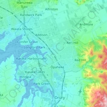
Name: Papakura topographic map, elevation, terrain.

Location: Papakura, Auckland, New Zealand (-37.11090 174.89889 -37.01059 174.99122)

Average elevation: 131 ft

Minimum elevation: 0 ft

Maximum elevation: 922 ft

Other topographic maps

Click on a map to view its topography, its elevation and its terrain.

Waiari Reserve

New Zealand > Auckland > Papakura

Average elevation: 39 ft

Lake Panorama

New Zealand > Auckland > Henderson-Massey

Average elevation: 171 ft

Pukekohe

New Zealand > Auckland > Franklin

Average elevation: 256 ft

Wilson's Beach

New Zealand > Auckland > Ōrākei

Average elevation: 69 ft

Omaha Beach

New Zealand > Auckland > Rodney > Omaha

Average elevation: 10 ft

Maraetai

New Zealand > Auckland > Franklin > Maraetai

Average elevation: 72 ft

Gear up for your next adventure:

🧤Tactile Hiking Gloves - Keep hands warm while operating GPS and smartphone screens
👓Polarized Sunglasses - Outdoor sunglasses for glare reduction
🔋Rechargeable Batteries - Power up your outdoor devices
📷Action Cameras - Rugged cameras to document your journeys across rugged terrain
📶Vehicle Signal Boosters - Improve reception in rural areas while driving to trailheads

As an Amazon Associate, this site earns from qualifying purchases at no extra cost to you.