
Make a donation
Gear up for your next adventure:
As an Amazon Associate, this site earns from qualifying purchases at no extra cost to you.
Briarcliffe Acres topographic map
Click on the map to display elevation.
Make a donation
Gear up for your next adventure:
As an Amazon Associate, this site earns from qualifying purchases at no extra cost to you.
About this map
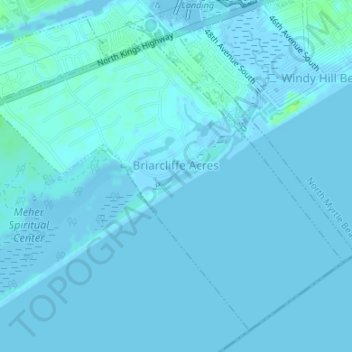
Name: Briarcliffe Acres topographic map, elevation, terrain.
Average elevation: 3 ft
Minimum elevation: -16 ft
Maximum elevation: 36 ft
Horry County trails, hiking, mountain biking, running and outdoor activities
Make a donation
Gear up for your next adventure:
As an Amazon Associate, this site earns from qualifying purchases at no extra cost to you.
Other topographic maps
Click on a map to view its topography, its elevation and its terrain.
Carolina Forest
United States > South Carolina > Horry County > Carolina Forest
Average elevation: 39 ft
Make a donation
Gear up for your next adventure:
As an Amazon Associate, this site earns from qualifying purchases at no extra cost to you.
Make a donation
Gear up for your next adventure:
As an Amazon Associate, this site earns from qualifying purchases at no extra cost to you.
Market Common District
United States > South Carolina > Horry County > Myrtle Beach
Average elevation: 16 ft
Make a donation
Gear up for your next adventure:
As an Amazon Associate, this site earns from qualifying purchases at no extra cost to you.
Futch Beach
United States > South Carolina > Horry County > North Myrtle Beach
Average elevation: 3 ft
Make a donation
Gear up for your next adventure:
As an Amazon Associate, this site earns from qualifying purchases at no extra cost to you.
Crescent Beach
United States > South Carolina > Horry County > North Myrtle Beach > Crescent Beach
Average elevation: 10 ft
Ocean Drive Beach
United States > South Carolina > Horry County > North Myrtle Beach
Average elevation: 7 ft
Make a donation
Gear up for your next adventure:
As an Amazon Associate, this site earns from qualifying purchases at no extra cost to you.
Seabrook Plantation
United States > South Carolina > Horry County > North Myrtle Beach
Average elevation: 10 ft